Category Archives: Spatial IT/GIS

Jordan Carmona, GISP
23 Young Geospatial Professionals to Watch in 2023 – 13 of 23 Name: Jordan Carmona, GISPCompany: Town of Prosper, TexasCurrent position: Senior GIS AnalystAge: 33 Education: BA in history and political science, University of North Texas Since his first position with a start-up IT and GIS services group, Carmona has had the opportunity to...

Sri Krishna Murthy Hari
23 Young Geospatial Professionals to Watch in 2023 – 12 of 23 Name: Sri Krishna Murthy HariCompany: Beans.ai Current position: Head of GISAge: 32 Education: MS Integrated Geospatial Sciences, Michigan Technological University Krishna leads the GIS teams in building detailed 3D maps and indoor routing datasets for essentially all the addresses in the...

Rachel Layko
23 Young Geospatial Professionals to Watch in 2023 – 9 of 23 Name: Rachel LaykoCompany: Arizona State University Current position: PhD CandidateAge: 25 Education: BS in biology; minor in marine science, The College of William & Mary In the PhD program at Arizona State University, Layko is working to bring her geospatial background...

Megan Young
23 Young Geospatial Professionals to Watch in 2023 – 6 of 23 Name: Megan Young Company: California Public Utilities Commission Current Position: Senior Spatial Analyst Age: 31 Education: BS Environmental Systems and Earth Sciences, University of California, San Diego Biography: Young is a leader, a trusted mentor, and a great advocate for the geospatial industry. She serves as...

In the Red
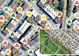
Thermal imagery helps reveal building heat loss Dr. Geoffrey Hay envisioned a solution for an invisible problem in a few milliseconds. Hay, a GIScience professor at the University of Calgary in Alberta, Canada, was perplexed by his higher-than-expected heat bills after moving into his new, modern home that was equipped with “energy-efficient everything.” It was...

Lauren McKinney-Wise
23 Young Geospatial Professionals to Watch in 2023 – 4 of 23 Name: Lauren McKinney-WiseCompanies: Portland Bureau of Transportation Current Positions: Graduate Assistant, GIS Lab Coordinator/Lead GIS tutor Age: 29 Education: GIS certificate, AS Portland Community College; BS in Geography with minor in GIS Portland State University; MS in Geography, Portland State University Biography: McKinney-Wise works...
