xyHt in print July 2014 Archives
How to Talk with Clients About Laser Scanning
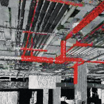
Clients should choose a laser scan primarily when they need to document existing conditions for a future construction or complex renovation project. When complex conditions exist, the risk of a mistake using a tape measure and sketch pad greatly increases the probability of a construction error. If this matches our clients’ needs, we then discuss […]
Sicilian Survey of the Norman Bridge

Standing at 10,970 feet tall, Italy’s Mount Etna dominates the eastern coast of Sicily and is the highest volcano on the European continent. At the foot of “the mountain,” as it is referred to by Sicilians, stretches a vast area of cultivated fields interlaced with a dense network of narrow streets bordered by the dry lava […]
Critical Issues for GIS/Survey Cooperation
State Plane Coordinates in Legal Descriptions The time is now to have State Plane Coordinates (SPC) attached to key monuments that should be part of just about any legal description, in the proper context.* This has been discussed since the early 1980s and has been accomplished only on a piecemeal basis. With coordinate inclusion, a […]