Tag Archives: 3D

Shining a Light Into Black Boxes
AI-infused 3D modeling of substations, pump houses, and other facilities offers utilities immediate benefit By Ben Dwinal Using advanced GIS systems, utilities can create detailed infrastructure models that enable them to deliver services to residents more efficiently and safely. These models include highly granular data about the networks of lines and pipes that deliver electricity,...
Introducing Exyn Nexys –
A modular mapping and surveying ecosystem that allows users to quickly capture highly accurate, colorized, real-time 3D point clouds in complex, dangerous, or inhospitable environments like those in the mining, AEC, and geospatial industries.

Mapping What Lies Beneath
The tools and resources for mapping underground infrastructure are rapidly evolving, but to keep up we must change our mindset of underground utility mapping.
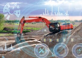
AI In Construction
AI is imperative to the future of the construction industry. It offers an intuitive way to automate tasks that free humans to focus on making the most critical decisions rather than the minutiae that wastes our time.

Preserving the World’s Cultural Heritage
Scanning the ruins of a castle in Romania will help preserve the country’s past and the literary myth of Dracula
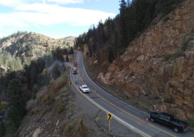
A New Perspective with Drone Photogrammetry
Geotechnical engineers say drones offer a safer, faster method of data collection to identify potential geohazards and assist with mitigation along vulnerable transportation corridors. Mountain roadways are prime locations for geohazards, such as rockfalls, landslides, and debris flows. These events result in road closures, injuries, and property damage, sometimes triggered by thaw/freeze cycles or...