Tag Archives: 3D
Virtual Reality and City Planning
Engaging citizens to participate actively in urban development projects can often be difficult. But rendering designs in 3D city models and transforming them into immersive virtual reality spaces might just do the trick. When it comes to reshaping cities and constructing new structures, modern architects consider public participation an essential part of creating sustainable and...

The Construction Automation Continuum
It’s more about many minor triumphs than major leaps. Surveyors can play an essential role in implementing these changes To those outside of the industry (and some within), the term “construction automation” evokes visions of bots and autonomous equipment plying construction sites—efficient and tireless—yet always on some far horizon. In present reality, construction automation takes...
Disruptive Lidar Tech
Technologies developed for autonomy and consumer applications are opening up new user segments and rewriting conventional workflows A construction inspector sweeps their phone over an open trench creating a 3D as-built of the utilities within. This is just one example of low-cost, rapid, simplified reality capture is challenging conventional wisdom on how reality capture should...

Beans.ai: Solves the Last-Mile Problem with 3D Indoor Routing
Sponsored Content

New Digital World Needs Data
Next-generation surveyors require specialized education and training to fill the role of geospatial data specialists. Many emerging geospatial applications, such as digital twins, 3D modeling, monitoring, virtual reality, and autonomous vehicles, are based on big digital datasets. Building a 3D digital world starts with accurate data that ties to a point on the ground, so...

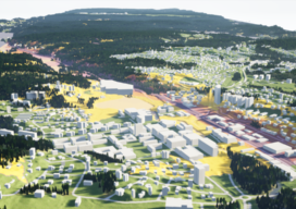
Virtual Cities Are Rising
Cutting-edge 3D city models lead the way to better urban planning via digital simulation Take a peek at Helsinki’s virtual 3D city model and what might at first seem to be just rows of solid objects soon reveal themselves as handsome blocks of buildings that line gridiron streets. This is the digital doppelganger of Finland’s...