Tag Archives: 3D

Repositioning GIS
The technology that will drive the next era Esri calls GIS the nervous system of the planet, a platform relevant to almost every human endeavor. It’s a way to display, manipulate, and analyze geospatial data—and that ability is ever changing and expanding across industries. GIS technology allows us to derive location intelligence from spatial and...

Street-Level Lidar On Demand
As exciting as the advent of on-demand access to current, high-resolution lidar is, so are the tools available for ingesting, extracting features, analyzing, and sharing. “What we’re hearing right now, this is really an inflection point for the industry,” says Phil Christensen, vice president for reality and spatial modeling at Bentley Systems. “The software has...

Sanborn Relies on Vexcel Osprey Systems
Sanborn Relies on Vexcel Osprey Systems to Meet Growing Demands for Oblique Imagery In response to growing demand for oblique aerial imagery in the vegetation management, tax assessment, and 3D GIS markets, the Sanborn Map Company purchased two Vexcel UltraCam Osprey systems to better serve those applications. The Colorado Springs company replaced its existing oblique...
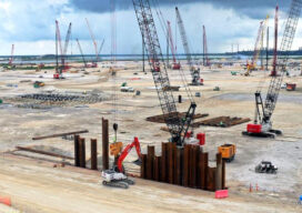
From Texas to the World
A $10 billion construction project will change the future of energy The task of getting clean, efficient energy created and distributed from Texas to the rest of the world is no small-or easy-task. And certainly not inexpensive. But the future of energy may well depend on the process of liquifying natural gas and shipping it...

That Scan-Do Spirit
Preserving heritage sites and objects is a race against time and elements. But thanks to scanning technologies, experts are now more confident humanity’s cultural legacy can be saved. One of the most iconic and visited landmarks in the world is the Notre-Dame Cathedral in Paris. So, it came as a shock on the evening of...

xyHt Weekly News Recap: 12/03/2021
2022 GeoWeek Awards Topcon opens new European distribution center in Zoetermeer Bluesky Aerial Photography used to Map Green Roofs NSPS Scholarship Applications Available LiDAR Market May be Worth $3.4 Billion by 2026 Capturing the Environment with a Lidar-equipped Helmet Advanced Aerial Mapping Provides Valuable Information to First Responders Generation of 3D Maps Placed in the...