Tag Archives: 3D

Everything you ever wanted to know about Mobile Mapping
Explaining the tools and technology behind mobile mapping devices for experienced laser scanning professionals looking to make the jump to this new technology. In its short life, the market for 3D as-built documentation technology has seen considerable innovation. Among the myriad new tools to hit this market, nothing has changed the way we capture buildings...

xyHt Weekly News Links: 9/18/20
Esri Releases 4th Edition of Getting to Know Web GIS Trimble Acquires MdStates VRS MGISS Reveals Underground Highway Assets IGARSS 2020 Hosts Geospatial Business Startup Workshop Spectra Receiver Chosen for Around-the-World Yacht Race Esri Acquires nFrames to Enhance 3D Capabilities
xyHt Weekly News Links: 6/12/2020
*Click here to visit xyHt’s Virtual Trade Show* Last Call for AEM Hall of Fame Nominations Lidar Finds Oldest and Largest Maya Monument What Lies Ahead for 3D City Modeling? Senators Want to Hear from FCC on Ligado Decision
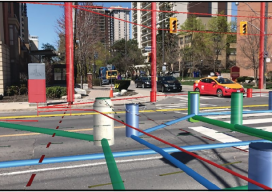
Hidden Infrastructure in 3D: Visualizing with AR
A visualization platform overlays data displays on your view of a job site by fusing data, AR software, and mobile-device sensors. From Superman’s x-ray vision, to current technologies that use radio waves to sense objects through walls. The ability, fictional or actual, to “see” through obstacles has long been a source of fascination. (Above: An...

What Is PostGIS Day?
For the last 20 years, we have celebrated GIS day along with Esri. It is a great opportunity to get people who haven’t used GIS or mapping before in your office to have a look at what you do and maybe share a map cake (Note: It is traditional for GIS professionals to make a...
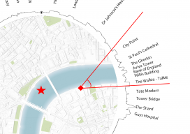
What’s within a 30-minute Walk – Revisited
I recently had reason to be in London for a short meeting and walked past London Bridge, looked at the sky around me, and thought, “I wonder how accurate that map I made last year is?” I was fortunate to have my camera phone with me so that I could take a few pictures. The...