Tag Archives: BIM
The Vanishing Divide
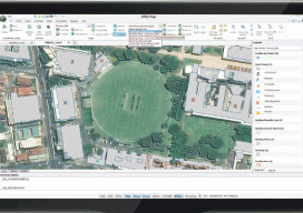
New solutions bridge the gap between CAD and GIS. Editor’s note: In our continuing examination of CAD-GIS integration we’ve presented several approaches and products. Internationally, a tremendous amount of work has been done towards integration, both in academia and in commercial software; here we introduce you to Graebert GmbH, German developer of popular CAD software...

Autodesk + Leica Geosystems
Two tech giants embark on a collaboration and education outreach. At June 2015’s HxGN LIVE (the annual user conference for Leica Geosystems and other divisions of Hexagon), we spied something rather surprising: an Autodesk booth. What’s more, someone at the booth was using Autodesk software for construction layout on a consumer tablet, driving a Leica...
Esri UK User Conference
May 22, QEII Building, London UK With a venue overlooking Westminster Cathedral and a stone’s throw from the Houses of Parliament, Esri couldn’t have picked a more British location for the UK annual conference. Last year (2014), there were a little more than 1,000 delegates; this year Esri UK played host to over 2,000, and...

Q&A with 3D Guru TJ McCue
Autodesk is sponsoring an eight-month 3D RV (recreational vehicle) 100 stop tour of the U.S. that celebrates the future of how things are designed and made. Led by TJ McCue, host, writer, and 3D enthusiast, the 3D RV tour is visiting America’s cities, towns and off-the-beaten path byways to explore a powerful and fundamental change...