Tag Archives: drones

It’s a Small (Sensor) World
The fascinating emerging world of geophysical and geological exploration with drones For the last 10 years we have seen more and more applications adopting uncrewed aircraft or drones and adding them to their workflows to expand businesses and offer more versatility to their customers. But like in every other new technology, adoption is not uniform,...

Behave Like Aviators
The importance of rules and conduct when flying small drones for mapping

Drones in School
STEM education is preparing the next generation of workers for exciting careers in technology-related fields.
A New Perspective with Drone Photogrammetry
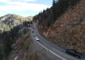
Geotechnical engineers say drones offer a safer, faster method of data collection to identify potential geohazards and assist with mitigation along vulnerable transportation corridors. Mountain roadways are prime locations for geohazards, such as rockfalls, landslides, and debris flows. These events result in road closures, injuries, and property damage, sometimes triggered by thaw/freeze cycles or...

xyHt Weekly News Recap: 10/06/2023
Topcon expands construction layout portfolio with LN-50 Cadcorp launches new EPC Data Service New Davis-Bacon Act Rules Go Into Effect Oct. 23 Esri and NSPS | Surveyors and GIS Webinar Series German campaign aims to get youngsters excited about mapping and surveying Drones Receive EASA’s C6 Certificate for BVLOS Flights in the European Union ...
The Next Big Thing
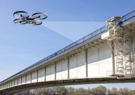
A string of high-profile bridge failures in recent years has underscored the importance of innovating the way we inspect and assess the condition of our vital civil infrastructure. Can the use of AI help prevent bridge collapses in the future? This award-winning engineer thinks so. The period spanning 1992 to 2014 could just be the...