The importance of rules and conduct when flying small drones for mapping
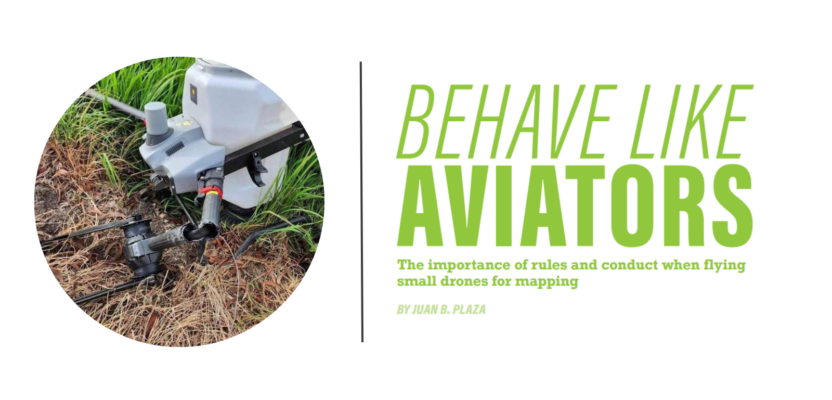
When I saw my first photogrammetry drone in 2013, it was all new and full of promise and wonder. As with anything else in life, with maturity comes reality and with reality comes responsibility. This past decade, the industry of aerial photogrammetry using small drones has grown exponentially and today there are a myriad of inexpensive solutions that have allowed surveyors all over the world to transition from purely ground operations to full blown aerial mapping capabilities relatively easily.
But what happens when hundreds if not thousands of small drones start sharing the sky with general and commercial aviation? The inevitability of an encounter grows with every flight and the need to be protected is more imperative than ever.
 On December 30, 2023, a Robinson R44 helicopter collided with a drone half a mile southwest of the Daytona Beach airport (KDAB) and at the beginning speculation was rampant and all kinds of rumors began to circulate given the combination of the words helicopter, airport, and drone.
Two weeks later the National Transportation Safety Board (NTSB) the independent federal agency that investigates transportation accidents in the country, published an “Aviation Investigation Notification” that lists all the facts of the accident, including all registration data for the helicopter, weather, and exact location. The curious thing about this preliminary report is that it does not mention the drone at all—not a single word about an uncrewed vehicle being involved in the accident.
We were able to dig a little deeper into the issue and found out the following facts:
- The drone was performing an automated photogrammetry flight at 180 feet AGL (Above Ground Level).
- The helicopter was performing a short tourist flight with one pilot and two passengers onboard.
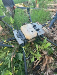
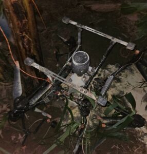
- The collision occurred over the mapping area when one of the blades of the helicopter hit the drone while the drone was flying a south-north line of its grid.
- Given the proximity to the airport, the drone mapping flight was being conducted under a Certificate of Waiver or Authorization (COA).
- The helicopter was not operating from the KDBA but from a private heliport half a mile southwest of the accident site.
- This particular flight of December 30 was the ninth flight being performed over the same area, over a similar number of weeks, beginning in early November.
- Both pilots have valid pilot licenses from the FAA, both aircraft are properly registered with the FAA, and both operations are legal under FAA rules.
- The helicopter suffered minor damage to one blade and the drone was destroyed.
It is very difficult to know exactly what happened before the NTSB publishes its final accident report. The NTSB normally takes a few weeks to publish a preliminary report and this was a Class 4 investigation, the lowest level given the fact that were no injuries or damage to third parties. Class 1 is for major accidents. Class 2 investigations involve a significant effort collecting evidence across several investigative areas and a substantial investment of resources. Class 3 investigations seek to identify safety issues that reveal underlying causes of the accident.
A few lessons can be learned from this event for everyone involved in aerial mapping with non-piloted aircraft, especially considering that it happened to a colleague of ours.
As soon as you take off, you enter a “System” in which you are just another player in the National Airspace (NAS), and you are bound to encounter other aircraft. This happens to every traditional pilot in almost every flight, and deviations are normal in both VFR (Visual Flying Rules) and IFR (Instrument Flying Rules).
 In my experience as a traditional photogrammetry pilot, in both jet and propeller planes, I have been told countless times to stop on a specific line in my grid and descend or climb or turn left or turn right to allow a passenger jet to traverse my mapping area. This is normal and we have all been affected by it. But what happens when there is no pilot onboard?
Very simple: follow the rules of Part 107. This uncrewed aviation regulation that took effect in the summer of 2016 is what most, if not all, drone pilots are using today to legally fly their drones and improve their workflows, from cellular tower inspections to photogrammetry.
Part 107 is restricted to flights within the visual line of sight of the operator and we are all anxiously awaiting the Federal Aviation Administration (FAA) to release what is expected to be called Part 108, regulating flights beyond visual line of sight or BVLOS.
But while we wait, let us focus on the minimum requirements that all drone pilots, especially those in our profession, must comply with, to be legally protected in case of an accident:
- Make sure you have all your certificates in order and up to date.
- Make sure the registration of the drone with the FAA is in effect and valid.
- Make sure you have hardware and liability insurance for your drone and the operation you are performing.
- Make sure that you can always keep the drone in your line of sight. If the operation requires you to see something else from time to time, hire a visual observer to help you always keep track of the drone.
- If you are flying under a COA, make sure you read every word and comply with every instruction.
- If the person responsible for the safety of the operation mentioned by name in the COA is not you, make sure that person is fully aware of your flight and, if possible, make sure that person is always with you while in the area of the flight.
- If the COA allows you to fly in the vicinity of an airport, make sure you communicate with the tower and that they have your phone number. Also, make sure you have your phone with you and that you can always hear it.
Drones in particular and uncrewed aviation in general will become more ubiquitous as people adopt the technology and civil aviation authorities around the world allow more and more operations of every type in their respective airspaces. In a very short time, there will be more uncrewed flights than traditional aviation and with that comes a huge responsibility for us as pilots.
Let’s not forget that once we take off, we enter the domain of the FAA and we have the same privileges of a larger, piloted aircraft but also that we are subjected to the same responsibilities and high safety standards. We are all aviators, and we all profit from the exploitation of this national resource, but let’s make sure that aerial photogrammetry and mapping will be the example of probity and good behavior that has always characterized our profession. After all we are the first professionals to enter a site and the last to leave.