Tag Archives: esri

My 2019 Interview with Jack Dangermond
Above: Dangermond and Duggan at the Esri UC 2019. What’s changed in a year? Editor’s Note: At last year’s Esri User Conference, writer Nick Duggan interviewed Jack Dangermond, co-founder (with Laura Dangermond) of Esri. At this year’s UC Nick spent time with Jack again to delve deeper. Nicholas Duggan: First, I need to thank you....

The Science of Where to Build Anything
Above: Both Esri and Autodesk have shown this graphic at their individual presentations. Will the Esri/Autodesk partnership take BIM head-on? In August 2018, xyHt editor Gavin Schrock sat down with Jack Dangermond and Andrew Anagnost, of Esri and Autodesk respectively. They spoke of the natural industry links between the two companies and how they were...

Esri UK Conference 2019 Recap
Every year towards the end of May, Esri UK, the UK distributer for Esri software, holds a user conference across the road from Westminster, the home of the UK parliament (when I was there I even got to see Jacob Reese Mogg). It’s held at the QE2 centre, and there are amazing views from the fifth floor which allow...
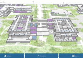
ArcGIS Indoors
What is it, and how will it work? Mapping has traditionally been the task of visually charting big outdoor spaces with pretty hills that look great with a few contours around them. Throw in a bit of hillshade, and you have a cartophile’s dream. The location intelligence company Esri, that has driven the market to...

Be Critical of the Data
Image above: The author’s view of Lake Michigan as he walked toward the lighthouse at Manitowoc. Not long ago, obtaining data for a surveying or GIS-based project was an arduous task. Because great time and effort was involved with either creating your own data or obtaining data that someone else created, you had to think...
Where on Earth Is the Offset in ArcGIS Pro?
Life used to be nice and easy for us GIS guys. We used to roll out of bed, click start on our GIS software, go back to bed for an hour, and then think about making a nice simple 2D map. Then, all of a sudden everyone starts talking about 3D GIS and being able...