Tag Archives: esri

My First Trip to the Esri UC
No matter what flavor of GIS you roll, there is no ignoring the annual Esri user conference in San Diego. The highlight is the opening plenary session which is always given by the (co) founder of Esri, none other than Jack Dangermond. To discuss this fully, we have to start at the beginning, which was...
Using Ortho Imagery (Digital Aerial) in ArcGIS Pro
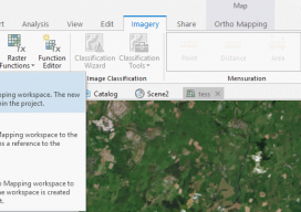
The new version of Esri’s ArcGIS Pro software offers the capability to use stereo imagery, something of great use to those looking to digitize and use 3D vector data. To this end, I thought I would try bringing in some stereo aerial data to see how the process works within ArcGIS Pro. Vague Knowledge At...

GEO Business 2018: “Geocoolness” in the London Heat
Trends in geomatics tech and spatial IT at the UK’s premier annual geo conference and exhibition Editor’s Note: GEO Business is an annual conference held annually in London. xyHt’s Europe editor, Nick Duggan has been attending each year, chronicling trends in the geo industry. The event is growing into one of the premier geo events...

Weekly xyHt News Links: 04/20/2018
SimActive Automates Drone Data Processing Exact Metrology Introduces Artec Ray Laser Scanner Teledyne Optech to showcase its Airborne and Terrestrial survey systems at GEOINT 2018 ENGINEERSUPPLY ANNOUNCES NEW PRODUCTS FROM SCHONSTEDT SPAR 3D Expo & Conference 2018 Keynote Speakers Announced Trimble Announces New Field Solutions for Land and Construction Surveying New Indoor Mobile Mapping System...

Taisha Waeny
Project Manager, Esri, in Australia and New Zealand We received multiple nominations for this dynamic geospatial professional from three continents. Taisha Waeny has become one of the most-recognized voices for the international community of Esri CityEngine users and the broader geospatial community, as well. Taisha encourages young people to enter the geomatics profession by pointing...
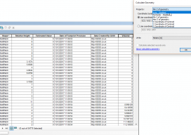
Calculating Geometry outside ArcGIS Pro
Let’s be clear: this isn’t a stab at the all-new, singing and dancing Esri software. This post is meant to help those who are using the software on a regular basis but finding issues with using the fields with multipatch data. Recently I’ve been working with calculating volumes of buildings that are multipatch data. For...