Tag Archives: esri

xyHt Weekly News Links: 9/18/20
Esri Releases 4th Edition of Getting to Know Web GIS Trimble Acquires MdStates VRS MGISS Reveals Underground Highway Assets IGARSS 2020 Hosts Geospatial Business Startup Workshop Spectra Receiver Chosen for Around-the-World Yacht Race Esri Acquires nFrames to Enhance 3D Capabilities
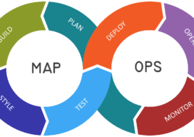
Let’s talk about MapOps
I’m not going to lie, I’m slowly mutating into one of those GIS high-level manager types who work less on real day to day map work and more about concepts and frameworks…even, at points strategizing. I hate it, give me some kriging interpolation or some hardcore viewshed analysis any day, but one thing is becoming...

3D and Geospatial Infrastructure
When I look ahead to the future of geospatial infrastructure and 3D, the words that come to mind are: more, faster, and … more! Humans are poor prognosticators when confronted with exponentially increasing or improving factors, and today we see an explosion of capability and content in the geospatial world that will lead to new...

Using Real Road Signs in GIS
At the moment, I am doing a little work with the construction industry that requires road signs and markings placed on a map to show where signs need to move as the site(s) moves through different phases. Now, a real cartographer nerd would say that good graphics and symbolization would negate the need for placing...
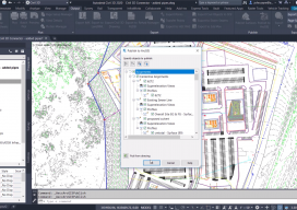
AEC Plus GIS
Above: You can connect to Esri’s ArcGIS directly from inside Autodesk’s Civil 3D. The Autodesk-Esri collaboration continues to lead the way in AEC+GIS with the announcement of significant, direct—and lateral—developments. Now entering its third year, the Esri-Autodesk collaboration launched in 2017 with great enthusiasm, as many practitioners in respective disciplines had been struggling with legacy...

Esri Partners with 3DR to Launch the ArcGIS Drone Collection
New Partnership Offers Users Best-in-Class Drone Data Capture and Analytics Solution on the Market Esri, the global leader in location intelligence, today announced that it has partnered with 3DR, a leading US drone data company, to expand Esri’s current drone imagery offering, Drone2Map for ArcGIS, with an end-to-end enterprise drone data and analytics solution for Esri’s...