Tag Archives: esri

GISWORX 2016
For most, work is a 9 to 5 grind that slowly eats at your core until you retire, find you have nothing to do, and get bored. Not if you work in the geospatial field though; everyday is a new adventure, and this month took me to the UAE, to be specific, Dubai for the...

QGIS 2.14 vs ArcGIS Pro 10.4
This post almost didn’t happen. For over seven years I’ve been comparing GIS software in the hope that someone would be reading and take it upon themselves to fix a few of the issues that we all run into on a daily basis. With the new releases someone told me something, and it almost stopped...
Mapillary Raises $8 Million Series A to Democratize Maps by Connecting the World’s Photos
Technology has made the farthest corners of the planet more accessible than ever before. We can video call loved ones on the other side of the world; and we can view photos of foreign landmarks at the click of a button. At Mapillary, we are taking this accessibility to the next level by letting anyone...

xyHt News Links: 1/22/16
EngineerSupply awarded Google Trusted Stores Badge Aerial Imaging Market – Global Industry Analysis, Size, Share, Growth, Trends and Forecast 2015 – 2023 Launch of the first satellite in the “SpaceDataHighway” programme Commercial drone sales to rise by 84 percent in 2016 Garmin acquires lidar company PulsedLight Prime Meridian on the move Juniper Systems Announces Mesa...
Bojan Šavrič
Software Development Engineer at Esri, Inc. Originally from Slovenia, Bojan Savric now works as a software engineer for the Esri projection engine team in southern California. He recently graduated with a PhD in geography, a minor in computer science, and a geographic information sciences graduate certificate from Oregon State University. Before moving to America, Bojan...
Hydro Insights
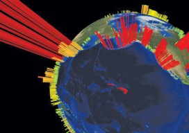
This visualization is of the high volume of commercial shipping activity into and out of ports rimming the Pacific Ocean. The data were analyzed using Esri’s new GIS Tools for Hadoop toolkit. Visualization by Mansour Raad, Esri. Available online at coolmaps.esri.com/BigData/ShippingGlobe with any browser running WebGL. Part 1: Uncharted Depths Editor’s Note: xyHt is honored to...