Tag Archives: forestry

Seeing the Trees and the Forest
How airborne lidar and hyperspectral imaging helps improve America’s green space and, ultimately, our quality of life

The Growing Use of Drones… In Crime Scene Investigation
With the sky darkening over an empty parking lot by the railroad tracks in Las Vegas, Nevada, the group of law enforcement professionals leaned in to hear Douglas Spotted Eagle, founder and director of educational programming at Sundance Media Group and a well-known industry figure, explain how drones would be used to capture the simulated...

xyHt Weekly News Recap: 07/09/2021
BlackSky’s Technology Monitors Iranian Nuclear Facility Microdrones and GE Launch the GE Industrial Drone Line Ag Department Selects NV5 Global for Geospatial Forestry Contract Graphisoft Releases Archicad 25 Uni-Pact USV Empowers FMS Next-gen Survey Work Esri Announces 2021 ArcGIS Online Competition Winners Satellite Imagery Company Satellogic to Go Public Through Merger New Software System Aims...
xyHt Weekly News Links: 10/16/2020
How UAVs Make a Difference in Modern ForestryNew Topcon Robotic Total StationEarth Define Maps U.S. TreesNASA to Study Trees Impact on Remote SensingHxGN Content Program delivers airborne DSM to the Federal Agency for Cartography and Geodesy (BKG)Ronda Schrenk to Serve as USGIF Foundation CEO
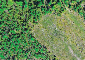
Lidar for Forestry
Above: Lidar-derived tree crowns and maximum tree-top heights are overlaid on a 20cm orthophoto. Vector-based products allow for a transition from the point cloud to GIS. A forester’s guide to understanding lidar topics, from upfront data-acquisition costs to business benefits to the path from research to operationalization. Although many lidar industry insiders never imagined the...