Tag Archives: lidar

Demystifying Mobile Mapping
Above: A mobile mapping rig of the engineering consulting firm Tetra Tech; the crew mapped the entire 288 miles of roadways in the city of Redmond, Washington in six days of driving. A surveyor examines (and asks users a lot of questions about) the Pegasus:Two system. Editor’s note: How could measurements taken from a moving vehicle...

UAS & The Combo that Opens Access
The most logical integration of technologies for surveyors is combining 3D laser scanning with UAVs. It’s no secret that many geospatial professionals are enamored with unmanned aerial systems (UAS). For many years, the pros and cons of deploying small UAS for mapping and surveying, along with their ongoing regulatory discussions, have been well researched and...
Reality Capture in 2016
An overview of criteria for obtaining and processing 3D data today. Above: Reality Capture has always played a role in the safety factor for surveyors and data collectors. Image courtesy of Olsson Associates. Ten years on, 3D and BIM are the de facto standards for design. It took firms a long time to recognize the...

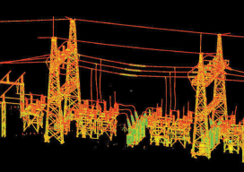
Shedding Light on Lidar
RIEGL USA’s CEO talks about the important trends in the lidar profession. For an inside look at the lidar profession, Heights interviewed James Van Rens, CEO of RIEGL USA. RIEGL provides a wide range of lidar scanning solutions for the aerial mapping and surveying profession, as well as mobile and terrestrial scanning applications. Van Rens...
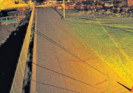
Prepping for El Niño
Above: A portion of a roadway that’s subject to flooding was scanned to perform drainage analysis as well as to map the existing conditions. As the severity of weather increases, so do the benefits of high-definition laser scanning for asset management and damage analysis. Editor’s note: Improvements in, and availability of, tools and resources for precise...
xyHt March 2016 issue
Click here to view the March 2016 issue of xyHt magazine.