Tag Archives: lidar

Shedding Light on Lidar
RIEGL USA’s CEO talks about the important trends in the lidar profession. For an inside look at the lidar profession, Heights interviewed James Van Rens, CEO of RIEGL USA. RIEGL provides a wide range of lidar scanning solutions for the aerial mapping and surveying profession, as well as mobile and terrestrial scanning applications. Van Rens...
Prepping for El Niño
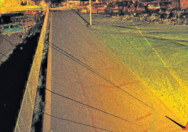
Above: A portion of a roadway that’s subject to flooding was scanned to perform drainage analysis as well as to map the existing conditions. As the severity of weather increases, so do the benefits of high-definition laser scanning for asset management and damage analysis. Editor’s note: Improvements in, and availability of, tools and resources for precise...
xyHt March 2016 issue
Click here to view the March 2016 issue of xyHt magazine.

xyHt News Links: 02/19/16
End-user Requirements for Satellite Imagery/Analytics from the Agriculture, Mining and Forestry Industries Seafloor Announces the Launch of Their Autonomous Surface Vehicles u-blox brings GNSS RTK precision to the mass market TerraGo and Eos Positioning partner on next-generation GPS/GNSS solutions DJI propulsion system aimed at industry, aerial imaging New ‘laspublish’ creates Web Portals for 3D Viewing...
xyHt News Links: 1/8/16
Phase One Industrial Announces 100 Megapixel Medium Format Metric Cameras for Aerial Data Acquisition CES 2016 – Inuitive and gestigon bring gesture recognition to embedded virtual reality platforms DAT/EM Systems International Releases 7.2 Septentrio’s Pinpoint-GIS is available on the ArcGIS Marketplace Leading LiDAR Expert, Tim Blak, Joins Atlantic Berntsen International ranked among top 300 B2B E-Commerce...

Wizardly 3D
Above: This hologram of a church in Texas was built from a combination of airborne and terrestrial lidar scans. More than just illusions, hologram technology is booming. Every once in a while a new product or technology comes out that makes you do a double take and think, “Wait, what is that?” This happened to me...