Tag Archives: lidar
True 3D Design
New geospatial software combines the appeal of games with the rigor of applications. It’s never been done before: applying the rigor and disciplines of civil engineering, mining engineering, hydrology, and even classic survey field-to-finish to game-like 3D design. Sure, CAD operators have had 3D viewing for years, which they use to review the results of...
Blending Realities
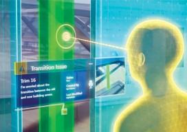
A 3D design and visualization tool with phenomenal potential in the AEC world is coming from a collaboration between Microsoft and Trimble. Imagine designing an object, in 3D and color, using only gaze, gestures, and voice (GGV) commands. Imagine designing an entire building the same way—or modifying an existing one. Imagine moving in a physical...
Easy Park Datasets
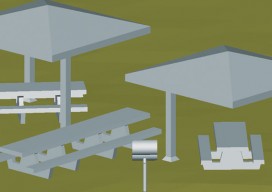
Above: Isometric view of 3D model of centralized benches, barbeques, and gazebos at Prescott National Forest. Collecting lidar data for as-built plans opt a busy national forest recreation site The Prescott National Forest (PNF) is a 1.25-million acre United States National Forest located in north central Arizona, with more than 20 developed recreation sites and an...

25 Tips for BIM
Expert Recommendations for Better As-built BIMs Creating as-built building information models (BIMs) has been greatly facilitated by the introduction of 3D laser scanners and modeling software, but the process still has its challenges. Four experts were asked to put their decades of combined scanning and modeling experience into this list of the best tips, tactics,...

Power Scanning
An electric utility in South Africa uses mobile lidar to manage costs and improve information flow. Founded in 1923 and based in South Africa, Eskom is a large company that generates, transmits, and distributes electricity; their customers are factories, mines, businesses, farms, individuals, and even other electricity providers. In fact, Eskom provides 95% of the...
Lidar for Forestry
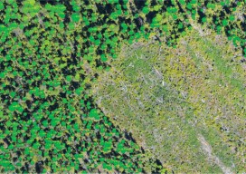
Above: Lidar-derived tree crowns and maximum tree-top heights are overlaid on a 20cm orthophoto. Vector-based products allow for a transition from the point cloud to GIS. A forester’s guide to understanding lidar topics, from upfront data-acquisition costs to business benefits to the path from research to operationalization. Although many lidar industry insiders never imagined the...