Tag Archives: NICB
Easing Post-Disaster Pain
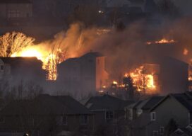
High-resolution aerial imagery of the Colorado Marshall Fire burn area expedited insurance claim process. With a long career in emergency management, Richard Butgereit is well aware of the devastating impact of natural disasters; however, his normal role is monitoring the event from afar and facilitating the assistance needed afterward. On December 30, 2021, in suburban...

xyHt Weekly News Links: 9/15/17
Tallysman introduces new high-gain GNSS antennas Taoglas launches comprehensive range of high-precision GNSS antennas NICB Makes Aerial Imagery from Harvey and Irma Available to Public Hazard and Evacuation Map Now Available for Hurricane Irma Affected Areas Drone swarm management software UgCS DDC enriched with ArtNET