Tag Archives: Pix4D

Lisa Chen
Surveying Solution Manager, Pix4D Switzerland Lisa Chen brings a unique set of skills, experience, and education to the booming fields of UAS-based and close-range terrestrial photogrammetry. One of the key markets for precise photogrammetry is surveying. And how fortuitous to have a surveying and geomatics engineer involved who also has experience in systems and software...

xyHt News Links: 11/18/16
Orbit GT and CycloMedia join forces with product integration East View Launches MapVault – Online Access to Authoritative Raster Maps Asteri Navigation Launches X-Series of Wearable GNSS Receivers at 2016 Autodesk University AT&T and NASA Collaborate on Drone Traffic Management System DJI offers large drone Matrice 600 Pro Harxon offers new waterproof helical GNSS antenna...
xyHt News Links: 2/12/16
Hybrid concepts as ideal drive technology for commercial UAV use Autodesk’s InfraWorks 360 Offering Simplified Pix4D and Parrot Release Precision Agriculture Solutions Topcon introduces newest data controller for surveying solutions Affordable All-In-One GNSS and RTK Data Collector Verisurf X9 Software Sokkia releases SHC500 field controller an open source street level photo viewer that can be...

Pix4D Mapper
Imagine walking up to an object with practically any camera and taking photos of it at different angles. Now imagine uploading those images onto a computer and being able to create a survey-accurate point cloud. Sounds impossible, huh? Too good to be true? That’s what I thought when I first heard of Pix4D. When I...
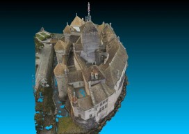
Chillon Castle: A Pix4D Sample Project
Above picture: Point cloud of full model of castle, shown from the top I wrote a review of Pix4D’s Mapper software in the November print issue of xyHt; check it out. Here’s Pix4D’s sample project to showcase the power of their software. They chose to create a model of Switzerland’s most visited site: the Chillon...