Tag Archives: point clouds

New Digital World Needs Data
Next-generation surveyors require specialized education and training to fill the role of geospatial data specialists. Many emerging geospatial applications, such as digital twins, 3D modeling, monitoring, virtual reality, and autonomous vehicles, are based on big digital datasets. Building a 3D digital world starts with accurate data that ties to a point on the ground, so...

Walden Environmental Engineering Captures New Insights and Revenue
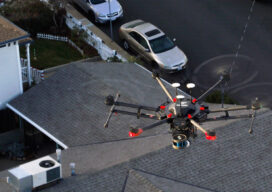
Emesent Hovermap was used by Harkin Aerial to conduct internal and external scans of assets for Walden Environmental Engineering. This resulted in simplified and streamlined projects with improved efficiency.
The Early Days of 3D Scanning: Part 14 & Final
Milestone advances since the early days got scanning to where it is now
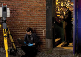
The Center for the Arts in Nevada County, California Optimizes Operations
Mobile LiDAR scanner Hovermap was used to conduct an internal and external scan of the facility in just over an hour to capture accurate as-builts and CAD drawings.

xyHt News Links: 12/2/16
Cadastral Boundaries from Point Clouds? Robotic Riverbed Survey Vessel Tracked with FOCUS 35 Total Station SimActive Enables Processing in the Cloud TerraGo Joins Trimble Developer Partner Program and Includes Trimble GNSS Direct SDK in Mobile Products Serious Gaming for Facility Management 11th Annual UAS Summit & Expo to take place in Grand Forks Boundless introduces...
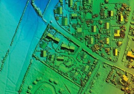
SGM
Obtaining economical and accurate point clouds from semi-global matching. In the old days, mappers were thrilled with 30 meter USGS digital elevation models (DEMs). These were available for almost everywhere in the United States. Years later they started producing 10m DEMs, and life was really good. We had one elevation point “on the ground” every...