Tag Archives: rtk

GNSS: Triple-frequency Constellations
Triple-frequency observations for high-accuracy positioning has been studied for years. It’s proven to greatly improve RTK performance (fix rate, reliability, and precision) in challenging scenarios for dual-frequency RTK, for example with a very a long base line, very active ionospheric motion, and a severe multi-path environment. Triple-frequency observations also help shorten PPP convergency time significantly....
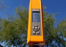
Bad Elf Flex – A Truly Affordable On-demand Accuracy GNSS Receiver
Sponsored by Bad Elf As the saying goes, “accuracy is addictive”. With the convergence of CAD and GIS, accuracy from plan to as-built embodies a critical need. Companies that monitor assets, support compliance needs or manage infrastructure, require systems that support high rigor for geospatial data. In this post, we talk with Larry Fox, Bad...
Dynamic Environment Data Collection
Swift Navigation’s Piksi® Multi is a multi-band, multi-constellation GNSS receiver that supports GPS L1/L2, GLONASS G1/G2, BeiDou B1/B2 and Galileo E1/E5b for RTK measurements and positioning and SBAS for robust sub-meter positioning in non-RTK mode. Critical to the accuracy of—and continuous improvements to—Swift’s receivers is ongoing testing in varying dynamic environments and conditions. This testing...

xyHt Weekly News Links: 8/4/17
Dewberry Honored for Special Achievement in GIS Reps. Westerman and Moulton Introduce Bipartisan Geospatial Data Act | Congressman Bruce Westerman GeoCue Announces GNSS Direct Geopositioning System for Low Cost DJI Drones Nearmap Provides High-Rez Oblique Imagery and 3D Products in Ready-to-Use Service ILMF Call for Papers Deadline is August 14! Congressman Doug Lamborn Addresses MAPPS...
xyHt Weekly News Recap: 5/19/17
Satlab Geosolutions introduces Ultra-Compact Multiconstellation GNSS UAV/RTK Receiver including Dual Antenna Heading capability senseFly Corridor solution boosts efficiency of linear mapping projects Icaros Releases Version 5.0 of OneButton™ Drone Image Processing Software Congress increases funding for UAS research, airspace integration Blue Marble Releases Mobile Friendly Version of the GeoCalc Geodetic Registry Swift, Carnegie release Duro for...
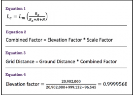
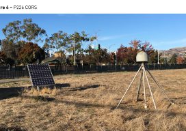
GNSS & Educational Equations: A Grid-to-Ground Project
When planning GNSS control surveys on highway projects, it is important to understand the limitations of GNSS. Most highway projects are long, and linear distances that are wide open horizontally and vertically and are ideal for GNSS surveying. However, in rural and city areas, tree canopies and high-rise buildings will obstruct the GNSS signals, so...