
Triple-frequency observations for high-accuracy positioning has been studied for years. It’s proven to greatly improve RTK performance (fix rate, reliability, and precision) in challenging scenarios for dual-frequency RTK, for example with a very a long base line, very active ionospheric motion, and a severe multi-path environment. Triple-frequency observations also help shorten PPP convergency time significantly.
In 2020, with Beidou3 and Galileo (nearly) put to full operation, we are about to see a lot more modernized satellites equipped with triple-frequency payload.
Let’s look at Beidou first, because Beidou is going to be completed in 2020 according to its official plan, which makes Beidou the third fully operational global navigation satellite system following GPS and GLONASS.
The full constellation of Beidou will consist of 24 MEO slots (24 Beidou3 satellites), six IGSO slots (3 Beidou3 + 3 Beidou2), and five GEO slots (3 Bedou3 + 2 Bedou2) (some Beidou orbit slots may have one Beidou2 satellite and one Beidou3 satellite, both operational; here we count it as only one Beidou3 satellite.). Beidou3 satellites transmit four open service signals at four frequencies: B1I at 1561.098MHz, B1C at 1575.42MHz, B3I at 1268.52MHz, and B2a at 1175.45MHz. We hope that Beidou will be the first fully operational constellation with all satellites transmitting navigation signals at triple or more frequencies (note 1).
Year 2020 would also be a significant milestone for Galileo. The full constellation of Galileo will consist of 24 MEO satellites and six active spares. Galileo has 22 operational MEO satellites at the end of 2019, and two more satellites are scheduled to be launched in 2020. Galileo is expected to complete its 24 MEO satellites of three planes, eight slots, which is the same as Beidou’s MEO number. The average semi-major axis of Galileo’s orbit is 29600 km, higher than BDS MEO’s 21528 km, which gives Galileo satellites better visibility. Galileo satellites transmit three open service signals at three frequencies: E1B/C at 1575.42MHz, E5a at 1175.45MHz, and E5b at 1207.14MHz (note 2).
GPS now has 12 operational Block IIF satellites and two Block IIIA satellites under testing (note 3). Three more Block IIIA satellites are scheduled to be launched in 2020. We expect that, by the end of 2020, nearly half of the satellites in GPS’s constellation are transmitting triple-frequency navigation signals (if we count four QZSS satellites as being in the extended GPS constellation). Users in East Asia and Oceania will find more than half of the tracked GPS satellites transmitting triple-frequency navigation signals (note 4).
Since 2018, GLONASS satellites have also started transmitting triple-frequency signals: L1OF at 1602MHz, L2OF at 1246MHz, and L3OC at 1202.025MHz. There are five operational GLONASS satellites (one GLONASS-K1 and four GLONASS-M) transmitting triple-frequency signals at the end of 2019, and we still won’t see many GLONASS-K available in 2020 (note 5).
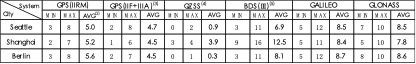
Above is a 2020 preview of GNSS satellites’ availability for users located in three cities: Seattle, Shanghai, and Berlin. The preview is based on the assumption that Beidou completes its full constellation, Galileo successfully deploys 24 MEO satellites, and GPS replaces at least three Block IIR/A satellites with Block IIIA in commission in 2020 (note 5).
Contributing author is Cheden Huang, director of R&D at Tersus.
Notes for Text
- Beidou2 satellites transmit 3 open service signals at 3 frequencies, B1I at 1561.098MHz, B2I at 1207.14MHz, B3I at 1268.52MHz.
- According to “Galileo E6-B/C Codes Technical Note”, Galileo E6-B (at 1278.75MHz) would be open service signal, but it has a 1000Hz symbol rate modulated on, which makes it not ideal for ranging purpose. Galileo E6-C (also at 1278.75MHz, the pilot component), may be encrypted in the future.
- Only Block IIF and Block IIIA/F satellites of GPS are capable of transmitting triple frequencies navigation signal at L1 L2 L5.
- QZSS satellites has almost the same scheme with GPS Block III satellites for civil signals, and QZSS system time is aimed to keep good alignment with GPS system time. It’s practical to treat QZSS satellites as extended GPS satellites for Baseband processing and positioning solution.
- https://en.wikipedia.org/wiki/List_of_GLONASS_satellites, 1 GLONASS-K1 702, 4 GLONASS-M 755 756 757 758
Notes for Table
- A satellite is considered to be observed when its elevation is greater than 5 degree.
- The average satellite number is calculated for 24 hours and the step is an hour.
- Navcen Constellation Status shows prn12, prn14 and prn18 will be replaced by a new sat.
- All Beidou’s GEO and IGSO satellites are located above from 76°E to 140°E, these satellites make Shanghai see much more Beidou’s satellites than Seattle and Berlin.
- The highest elevation of QZSS satellites is about 15 degrees in Seattle and about 10 degree in Berlin.