Tag Archives: state plane coordinates
State Plane Coordinates 2022
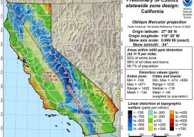
Ready or not, here they come. Considering all of the outreach that the National Geodetic Survey (NGS) has been doing for the last couple of years, hopefully most of you are well aware of the National Spatial Reference System (NSRS) Modernization Project. That project will result in the replacement of both the North American Datum...

Transformation of Observations, Part 4
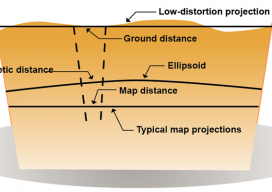
Single Project Factor Here concludes a four-part series of articles about transformation of observations, spanning from September and December 2014 to March 2015. Part 1 covers how to transform surface observations into a geocentric coordinate system so that they can be compared to GNSS baseline vectors. Part 2 is about how the creation of a...
Single Transformation with ECEF
We at xyHt think this topic is one surveyors should be talking about. Instead of placing this reader’s letter to us as a comment under Dr. Ghilani’s article (linked below), we are making it a post itself to encourage discussion underneath. Editor Gavin Schrock, PLS, started us off, below. Professor Ghiliani’s article, Transformation of Observations...