Tag Archives: USGS

xyHt Weekly News Recap: 06/28/2024
The Black Cape Scholarship for Women in Geospatial Intelligence EUSI Delivers SAR Imagery to DLR for Rapid Mapping of Southern Germany Floods Smart Cities Increase Drone Usage Worldwide Woolpert to Collect Aerial Lidar Data Across So. California for USGS Surveying Equipment Market size is set to grow by USD 2.72 billion from 2024-2028
xyHt Weekly News Recap: 12/23/2022
Worldwide Demand for Drone Services Anticipated to Reach $25 billion by 2033 USGS Recognizes Sanborn Expertise in AI/ML for Natural Resource Mapping Asia’s Leading Geospatial Event Returns to Singapore March 15-16 Airbus Hits Milestone on European Satellite-based Navigation Augmentation System Market for Commercial Earth Observation Data to Reach $7.9 Billion by 2031 Satellite Demand to...

On the House
Free data make the mapping world go round Reliable geospatial data used to be hard to find and expensive. But thanks to the profusion of online data repositories, it’s now at our fingertips for free. It is telling that one of the first websites where mapmakers can have access to free satellite imagery was created...

What to do With All the Lidar Data
An age-old Aesop’s Fable adage says, “Be careful what you wish for, lest it come true!” When the U.S. Geological Survey (USGS) embarked on the National Enhanced Elevation Assessment (NEAA) in 2012, the goal was to document the national-level requirements for enhanced elevation data. Little did USGS know at the time, the report would be...
xyHt Weekly News Recap: 04/22/2022
Biden Administration Plays Up Billions for Rural Infrastructure AGI Welcomes Business Development Specialist Angela Arriaga Trimble and Infotech Expand Collaboration to Improve Inspection Efficiencies for Infrastructure CHC Navigation Introduces Airborne Lidar Series Drone Nerds Displays Emerging Drone Technology Solutions at AUVSI XPONENTIAL NSPS Cosigns USGS Streamgages Letter PAR Government and BlackSky Deliver Near Real-Time Imagery Russia is...
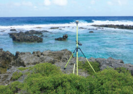
Island Hopping
Using topo-bathy lidar to map distant islands helps develop high-resolution 3D topographic data for the U.S. and its territories