Tag Archives: USV

Ocean Mapping Effort Makes Progress
Two new partnerships will advance Seabed 2030’s mission to map the entire ocean floor this decade Since ancient Egyptians began studying the Nile River, bathymetry has been the crucial component in hydrography. The great river gave rise to their great civilization, providing fertile soil for farming, water for irrigation, and a means of transportation...
Ocean Observation
Monitoring and comprehensive data collection is now a national security imperative For most of the second half of the last century there was general agreement that the primary existential threat to humanity was the purposeful or accidental exchange of nuclear weapons. While that threat has not been completely eliminated, in the 21st century there is...
Looking Forward: Up Above and Down Below
by Jeff Thoreson TWO MAJOR ASPECTS OF THE FUTURE OF THE GEOSPATIAL INDUSTRY don’t have much to do with surveyor boots on the ground—or the ground at all. The next few years of progression in our fields will have a lot to do with what flies above and what lies beneath. Unmanned aerial vehicles—a politically...
No Barrier Between Land and Water
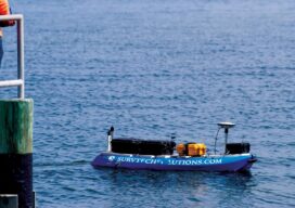
Innovative tools and technology help hydrographic mapping deliver detailed data in previously inaccessible areas. Underwater mapping presents unique logistical challenges that are increasingly being met with technology used in creative ways, and by combining multiple types of data to develop a complete picture. From unmanned surface vessels (USV) to multi-beam sonar, advanced equipment yields accurate...
New Horizons in 2022
News from The Hydrographic Society of America For those that are not too familiar with this organization, The Hydrographic Society of America Inc., also known as THSOA, is a non-profit professional membership organization, whose main focus is to provide support to its members in the Americas. We are a 501(c)(3) non-profit organization committed to promoting...
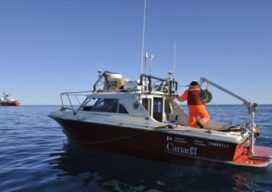
Surveying Beyond the Water’s Edge
A remotely controlled unmanned survey vessel gives a land survey crew full hydrographic abilities for two busy marinas in Oregon. Founded in 2005, Statewide Land Surveying (SWLS) is a small business located in Gresham, Oregon, well acquainted with taking on challenging projects. While mostly engaged in land surveying, SWLS crew members have been involved for over...