Innovative tools and technology help hydrographic mapping deliver detailed data in previously inaccessible areas.
Underwater mapping presents unique logistical challenges that are increasingly being met with technology used in creative ways, and by combining multiple types of data to develop a complete picture. From unmanned surface vessels (USV) to multi-beam sonar, advanced equipment yields accurate information about hydrographic features—oceans, rivers, coastal areas, and ponds—to produce seamless models incorporating land and water.
Growing Demand for Hydrography
SurvTech Solutions, based in Tampa, Florida, has experienced a steady increase in demand for hydrographic mapping as improved equipment makes new scientific and commercial applications feasible. Concerns about climate change, rising water levels, coastal erosion, etc., are also making funding more readily available. For example, the Resilient Florida Grant Program committed nearly $700 million to fund coastal protection and resiliency projects.
Founded in 2004, SurvTech has grown to 95 employees and expanded into multiple areas of geospatial services, including conventional land surveying, hydrographic surveying, sub-surface utility mapping, geophysical mapping, aerial mapping, and metrology (precision industrial surveying). SurvTech specializes in performing hydrographic surveys in difficult environments, including those with limited access and/or acidic water conditions. Its willingness to experiment with new tools and technology allows the firm to apply the best approach for every project, which can mean laser scanning, imaging, sonar, or other techniques, acquired with drones, fixed-wing aircraft, unmanned surface vessels, boats, or other platforms.
“When we started conducting hydro surveys, we had a 13-foot Boston Whaler boat and a single-beam echosounder, but we’ve greatly expanded our resources over the years,” said David O’Brien, president of SurvTech. “Game changers for our hydro department include multi-beam sonar for better coverage, an IMU incorporated into the sensor for better positioning accuracy, and one-manned and unmanned vessels that can access hard-to-reach places.”
Hydrographic projects cover a wide range of applications. To comply with regulations, industrial sites, such as mines and power plants, carefully monitor their waterbodies for water storage volume and sediment build up. Ports measure the depth of channels for ship clearance and periodically check the condition of underwater infrastructure. Unexploded ordinance is typically mapped with multi-beam and side-scan as they rest on the surface of the seabed, while underground pipelines are located using a combination of sub-bottom profilers, seismic sensors, and dual-frequency single-beam sensors. Maps of the ocean floor combined with wind, current, tide, and temperature data contribute to better weather forecasts, while near-shore mapping is used to study coastal erosion and mitigate flooding. There is a wealth of information under the water.
Integrated Data for Comprehensive Information
SurvTech often combines data from multiple sensors to provide critical information to its customers. One representative project is the Port of Miami Government Cut, the main ocean entry into the Miami area at South Beach. The inlet connects local and transatlantic traffic with the port facilities, and the jetty protects the manmade shipping channel. SurvTech collected UAV lidar and acoustic bathymetric data to support design and rehabilitation initiatives around the jetty for the U.S. Army Corps of Engineers (USACE).
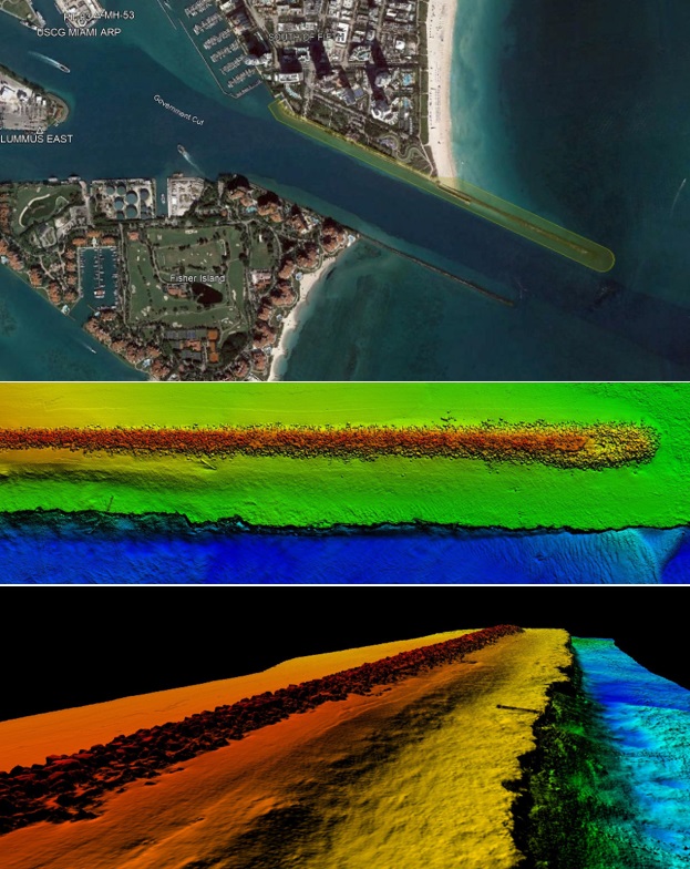
Top: The manmade Government Cut shipping channel at the Port of Miami is protected by a jetty. Middle and bottom: Processed together, multibeam sonar and UAV lidar data provide a cohesive, seamless data set. Credit: SurvTech Solutions.
For this project, a 25-foot survey vessel equipped with a Norbit iWBMS integrated multi-beam sonar collected data along the jetty at high tide. Hypack RTK tide values were cross-checked against a secondary GPS rover and verified against a nearby NGS benchmark. Additional data was acquired with an Edgetech 4125 side-scan sonar. A Harris H6 Hybrid UAV equipped with a Riegl Vux lidar system was used to collect high-density lidar data of the upland portion of the project, including the jetty, surrounding beach, and wharf. The multi-beam sonar and UAV lidar data was processed as a cohesive, seamless data set and delivered in LAS format.
“We typically combine several different types of surveying into one project, using a variety of equipment, software, and platforms to obtain the most accurate and highest quality data possible,” said Henry Simpkins, metrology department manager at SurvTech. “Overall, the equipment is getting smaller, faster, and easier to work with, like a Zego boat, which can be launched and operated by one person and go where a full-sized boat won’t work.”
To demonstrate how much information could quickly be gathered with a variety of methods, SurvTech worked with a group of other survey firms during a 2019 conference to create a 3D model of the Tampa Convention Center. Lidar and RGB imagery was collected with a drone, terrestrial lidar was scanned from a tripod, and the surrounding waterways were mapped with multi-beam sonar mounted on a small USV. Other participants operated a mobile mapping system mounted on a vehicle to laser scan the structure at street level and interior data was captured using GeoSLAM technology.
“This was an all-hands-on-deck effort to demonstrate how survey technology can be integrated in an emergency, such as quickly establishing a military base,” explained O’Brien. “We created a comprehensive 3D model of the convention center using multiple sensors and platforms. The results were very impressive.”
Exciting Future Developments
New tools and technology for hydrographic mapping make data collection feasible and efficient in previously inaccessible areas. Autonomous surface vessels carrying object avoidance technology and powered with solar panels and diesel for backup are mapping the ocean floor successfully, while new aerial bathymetric sensors are showing promise for high-volume topo-bathymetric mapping along coastlines.
“Going forward I see a big push toward aerial multi-beam data collection from airplanes and drones,” said Simpkins. “With the improvements in depth penetration, depending on water clarity, aerial is the fastest way to cover many miles of coastline. Also, remotely operated vehicles (ROVs or underwater drones) will be more common. Development of all kinds of autonomous vehicles will continue to provide new opportunities for hydrographic mapping.”
Linda Duffy is president of Apropos Research, Golden, Colorado, an independent market research firm that provides market research and marketing communications services to the geospatial and remote sensing community.
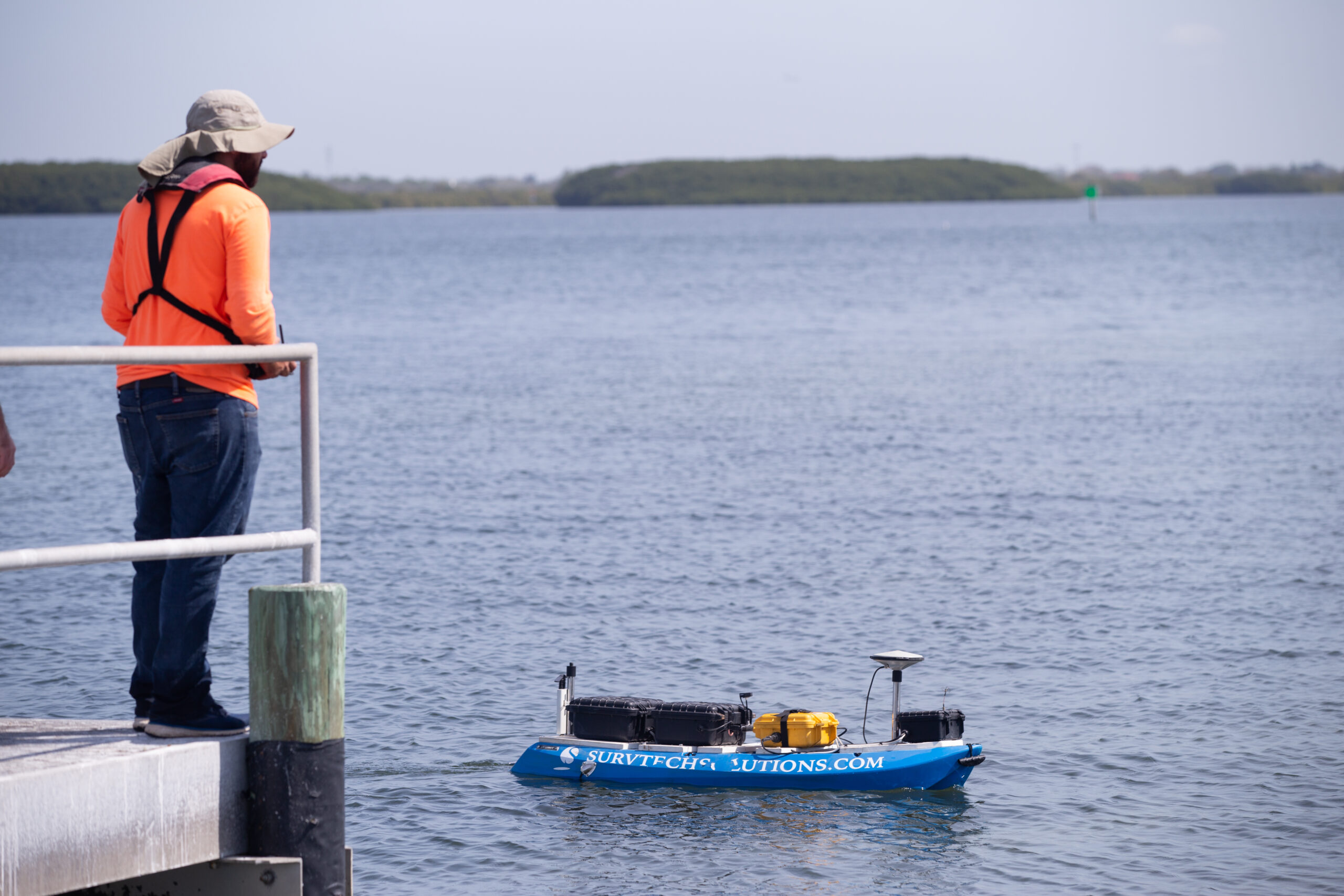
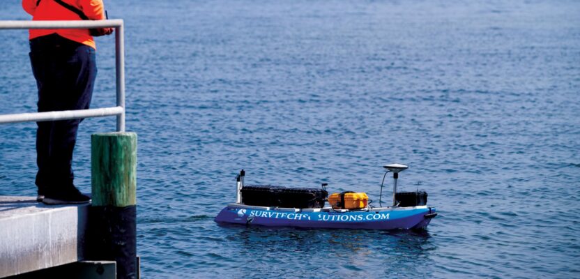
Unmanned surface vessels equipped with new technologies are expanding underwater and near-shore surveying capabilities. Credit: SurvTech Solutions.