A remotely controlled unmanned survey vessel gives a land survey crew full hydrographic abilities for two busy marinas in Oregon.
Founded in 2005, Statewide Land Surveying (SWLS) is a small business located in Gresham, Oregon, well acquainted with taking on challenging projects. While mostly engaged in land surveying, SWLS crew members have been involved for over two decades in shallow water hydrographic work throughout the Pacific Northwest.
SWLS staff have surveyed projects from coastal estuaries to rock quarries to major rivers such as the Cowlitz, Deschutes, and John Day. Over the firm’s 13-year history, crews have run cross sections using rope guns and belay systems, jetskis, and inflatable catarafts and kayaks. A dry suit is standard issue for field crews, as is the skill of treading water with one arm while keeping plumb a prism or even a $20,000 GPS overhead.
Measuring by a surveyor’s standard is rigorous, in a tradition of measuring and mapping as accurately as possible while resolving surveys within historical and environmental contexts, following in the footsteps of those who came before. With the knowledge that work will also be retraced and remeasured, physical challenges must be overcome to obtain information that is precise, accurate, and provable.
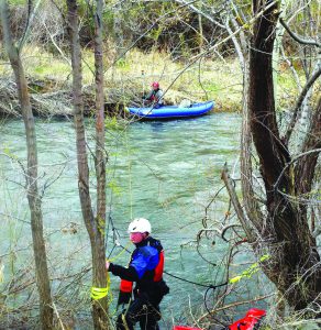
Before acquiring the USV, the survey crew employed a Z-drag and belay system to perform cross sections on the John Day River, Oregon. Kyle Rygh is in the foreground and Jason Churchill is with the kayak.
This professional responsibility extends beyond the water’s edge, even if it means SWLS surveyors must map sandbars by foot for over a quarter of a mile, taking shots at two-foot intervals near the confluence of the Cowlitz and Columbia rivers to acquire data where their 17-foot sled boat could not take them.
This quest for survey data of appropriate quality beyond the water’s edge is greatly influenced by the tools used to conduct the survey. While traditional land methods such as point GNSS or total station surveys are often suitable for small hydrographic surveys, being tied to these methods for larger-scale hydrographic projects may increase needed manpower resources and time. In some cases, accuracy may even start to degrade as more work-arounds are needed simply to obtain a measurement.
Many land survey firms such as SWLS have added echo-sounding capabilities to their toolbox, vastly improving productivity. Basic echo sounders can interface directly to a GNSS data collector and collect bottom elevation data in a continuous mapping mode. These systems are easy to use but suffer from a lack of quality control; the echo sounder is using a sound pulse to infer the depth—and that inference may be biased by several factors.
More advanced echo-sounder systems provide definitive QC, partly from the use of dedicated hydrographic software, but for hydrographic surveying they require the investment in equipment and skills to move past the data collector. It is the decision to push past the GNSS data collector and start surveying with fully hydrographic methods that allows the maintenance of survey accuracy even while vastly improving productivity.
With the recent emergence of unmanned vessels in surveying, SWLS looked to leverage unmanned technology while expanding their hydrographic surveying portfolio and improving efficiency. Overall, the firm was looking for a high degree of technology but also something practical in terms of learning curve, usability, and efficiency.
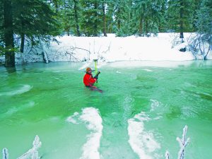
Surveyor Jason Churchill braves the frigid waters of Early Winter’s Creek near Mazama, Washington.
Working with Carlsbad, California, hydrographic equipment manufacturer CEE HydroSystems USA, SWLS acquired a remotely controlled unmanned survey vessel (USV) with the ability to collect high-resolution bathymetry data points and transmit the data in real time: a flexible option for beyond the water’s edge (and maybe reducing the need for one-arm water-treading).
Detroit Lake Marina Surveys
In August 2016, SWLS was approached with the task of conducting pre- and post-condition surveys of two marinas on Detroit Lake, Oregon, a reservoir that serves as a popular recreational area. The community’s economy, based on the tourism generated by the lake, is subject to the yearly changes in precipitation and water and power usage driven by the Detroit Dam. Because of concerns over recent seasons with drastically low water levels, both marinas had proposed to dredge in order to maintain a water level sufficient for their floating ramps and docks.
For SWLS, that meant delivery of survey-grade hydrographic surface models of two sites for dredge “pay grade,” roughly 12 and 9 acres, with steeply sloping banks of scree, depths over 50 feet, and docks and traffic that come with a marina operating near peak season.
Unmanned Surveying in Action
Detroit Lake presented an ideal opportunity for SWLS to use our new CEE-USV remote survey boat. The SWLS crew (including me) began by establishing a project control using GPS checkpoints and setting a base station on a nearby NGS benchmark. We delineated the shorelines of the sites and waded as far as possible to measure the lake bottom at each marina. We also carried their measurements upland past the visible high-water mark.
For USV operations, a Trimble R8 GNSS mounted on the USV passed NMEA data to the CEESCOPE survey echo sounder unit inside the USV. Sonar data acquisition, processing, and telemetry was handled by the CEESCOPE and telemetered to a laptop connected to USV’s CEE-LINK telemetry base station.
Position and depth data were displayed real-time via Hydromagic software (by Eye4Software in the Netherlands). The USV was navigated by a long-range 2.4 GHz controller, affording the operator the ability to use vantage points from the high-ground shore station or on the floating docks.
Before beginning survey sessions, the field crew checked the entered offsets and draft, calibrated the echo sounder’s sound velocity with a bar check, and conducted baseline measurements of the water surface elevation (WSE).
The crew performed vessel position checks twice daily by placing the GPS head mounted aboard the USV plumb over control points at each marina and recording measurements using Hydromagic. These horizontal and elevation settings could be verified against reference GNSS measurements. The echo sounder was calibrated for the project using traditional bar checks and lead line methods at several depths.
At the beginning and end of each day’s survey, WSE checks were made using the Trimble R8 rod. These measurements served as comparison references to the day’s log of moving “RTK tide” WSE measurements collected at 5Hz during USV operation. The GNSS RTK tide measurements meant each sounding—collected at 20Hz—could be attributed an accurate elevation value.
The CEE-USV allows recording raw data on the USV itself. Simultaneous telemetry to a hydrographic acquisition software package such as HYPACK or, in this instance, Hydromagic running on the shore computer provides a visualization of the echo sounder results, full-water column echogram to monitor sounding accuracy, WSE values, instrument operations, and data recording and storage.
Compared to a simple pole-mounted echo sounder and data collector, the confidence in sounding accuracy is greatly enhanced. This is all available to the operator in real time.
After delineating the project boundaries and shorelines for the marinas with their land survey set up, the crew laid out our cross-section survey lines at 15-foot intervals in Hydromagic. As the USV was driven across the marina, the Toughbook displayed the position tracking along with the option of left-right indicator to show distance of drift off-line.
While collecting a depth measurement every few inches, the crew recorded survey lines, then stopped or paused after each line. This method greatly facilitated organization and interpretation of such a large dataset. Each cross section could also be analyzed in the field where erroneous spikes, gaps, or artifacts could be removed. Where a known obstruction, a lost GPS fix, or any object of interest came up, a reference waypoint could be created and stored in the map. These QA/QC measures enabled proper management and accuracy for the project.
Finally, section lines were run perpendicular to cross-section lines across the marina sites; while we were evaluating the dataset, intersections of the sections lines and crossing lines provided elevation value comparisons as another vital QA/QC check.
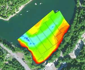
An elevation gradient generated in Hydromagic shows the Breitenbush River channel and footprint of the Detroit Lake marina boardwalks in Oregon.
Survey Challenges and Closure
The logistics of the project provided a unique challenge—navigating a site crowded with marina infrastructure, tight spaces, and open stretches of wind and waves. The CEE-USV was an effective solution, with high maneuverability and an effective range of up to about 3000 feet and a maximum speed of 9 knots—useful for high-speed river cross sections.
The USV even made the half-mile trip between marinas, preventing the need to mobilize at the second site; instead, the operator drove the boat while standing on the Highway 22 bridge between sites.
Even with a small boat about 6 feet long, the presence of boat-occupied slips along with rigging, bumpers, and floats left gaps in the dataset. To improve coverage further, the CEESCOPE echo sounder was simply removed from the USV; this allowed the crew to mount a second transducer to the bottom of their 2-meter GPS rod and mobilize the operation by walking around the floating dock while the recording was toggled on/off as the rodman worked his way around obstacles.
A critical aspect of the project was for the surveyors to have checks during the data-collection process. Spot-checks were taken along various points of the dock using a traditional lead line, as the docks provided a unique opportunity to verify sonar measurements against a tactile one at depths of up to 50 feet without using a boat.
Additionally, closure was brought by collecting overlapping data with a rod by wading as far as possible along cross-section lines at the shore. Data were cross-referenced to identify gaps that needed to be filled as they surveyed with either instrument.
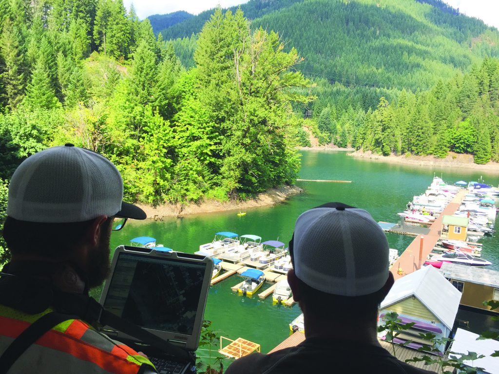
A two-person survey crew (the author at left and Jason Churchill) operate their CEE-USV remote boat from a vantage point at Detroit Lake Marina, OR.
Processing and Delivering
The project took the two-person team three days to complete and then deliver the data back to the office. Even with the equipment being new to SWLS, the speed on which the survey can be accomplished was obvious. This is especially the case after procedures and equipment setup routines are established that can be used time and again.
Hydrographic acquisition, unlike GNSS measurements, is not a precise single measurement but rather a high-rate, steadily repeating sounding measurement: in the case of the CEESCOPE, 20 soundings per second. With a sonar pulse used to detect a bottom substrate that may be poorly defined, covered in debris or vegetation, it is necessary to “paint” the bottom with sonar to precisely track features and identify the “real” surface of interest.
Back in the office, this methodology resulted in another learning curve once the data was reviewed for processing: seeing over 100,000 individual points appear on the screen. The data processing workflow involves qualifying the soundings, making any edits, and then generating substantially thinned sounding files from the raw data, with an average interpolated elevation value computed for every fixed position. Points could be filtered by GPS solution quality and elevation thresholds, among other variables.
The ability to view, process, and analyze data quickly in the field reduces the potential for excessive office-side reworking. Additionally, Hydromagic cross-section statistic reports could be run from lines with overlapping data points. The resulting point file consisted of readings every few inches that achieved the desired accuracy within ±0.2 feet that was ready for the generation of TIN and contours.
The versatility and relative in-use simplicity of the single-beam echo sounder system are among its key assets, and quality and quality control are not sacrificed to achieve this. Using a single-beam echo sounder (and not a more advanced but higher complexity multibeam swath system) saves time in the setup, data processing, and analysis.
For SWLS client surveys beyond the water’s edge, single beam provides a sufficiently dense data set while avoiding the patch tests and inertial motion sensors and myriad considerations that come along with running a multi-beam system. In the end this saves client costs.
SWLS’s experience with the USV and new hydrographic processes has given them opportunities to use advanced survey instrumentation and design operational survey procedures to generate accurate models they can be statistically confident in.
Throughout, it was imperative to have knowledge of survey fundamentals (geoid models, projections, and coordinate systems), situational awareness (rod heights, draft, power management, going to rescue your boat tied up in some hidden rope with a good ol’ canoe), and skills of observation and ingenuity (equipment operation and troubleshooting) that make up the intangible skillset that the surveyor carries with them every day.
Sidebar: The Party Chief Perspective Party chief Jason Churchill has spent more time than he may care to remember stabilizing a rod against the elements, treading water, and working along a safety rope. While he still anticipates having to get wet now and again or break through ice to get those shots, he was impressed by the capabilities of the USV and the data consistency and quality control from the advanced echo sounder on board. “The USV ultimately gives the surveyor another tool in a toolkit that is rapidly changing to maintain competitive survey options for clients,” he said. Having witnessed firsthand the evolution of technology and techniques during a survey career of more than 20 years, Jason can easily identify improvements that have made his job more efficient and his results more accurate. Working on the Oregon Science and Health University’s South waterfront redevelopment project in the late1990s, he remembers shooting 2,500-foot shots from the bank out to a boat 2,500 feet away on the Willamette River, where the crew radioed depths to him from a fish finder as he keyed in the entries. On another occasion in the mid ‘90s performing a survey for a flood study on the Wilson River, he recalls using two 16-foot dowels lashed together with a prism duct-taped on top to measure down from a bridge. “Surveyors are great at measuring x, y and z you know, so if you put a rod to the bottom of the river you know its gotta be right—with exception, when you’re measuring the Wilson River at flood stage and your 16 foot dowel bows out 4 feet, but that’s what you get when you’re dealing with two 100-year flood events in the same month and winds gusting over 100 miles per hour.”
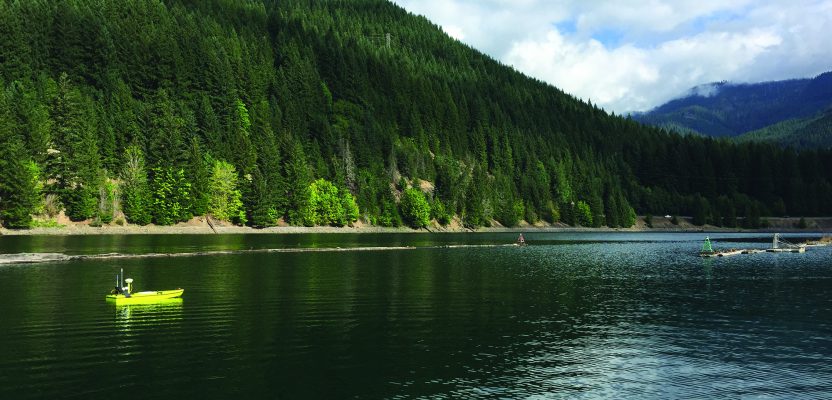
Image at top: The CEE-USV remote survey boat at work on Detroit Lake, OR.