Two new partnerships will advance Seabed 2030’s mission to map the entire ocean floor this decade
Since ancient Egyptians began studying the Nile River, bathymetry has been the crucial component in hydrography. The great river gave rise to their great civilization, providing fertile soil for farming, water for irrigation, and a means of transportation for materials that enabled great cities—and great pyramids—to rise from the desert.
Because the Nile was so vital, ancient Egyptians learned everything they could about it, understanding its depths, currents, and flooding potential. In the 5,000 years since, humans have managed to more accurately map the moon and Mars than the bottoms of our great waterways, especially our oceans.
Recognizing this, the Seabed 2030 project hopes to do in this decade what humanity hasn’t been able to accomplish in several millennia—create a map of the ocean floor to help us understand everything from navigation (more than 80 percent of global trade by volume is transported by sea) to climate change.
From the beginning of the seabed project, stakeholders knew that a key component of creating a high-resolution map of the seabed would be developing new technologies. Just this year, two new partners to Seabed 2030 are doing just that, making the monumental goal seem a little more attainable.
Seabed 2030 is a collaborative project between The Nippon Foundation and the General Bathymetric Chart of the Oceans (GEBCO), and the goal is not only mapping the world’s ocean but compiling the data into the freely available GEBCO Ocean Map. GEBCO is a joint program of the International Hydrographic Organization (IHO) and the Intergovernmental Oceanographic Commission (IOC) and is the organization with a mandate to map the entire ocean floor.

Richard Jenkins
“A complete map of the ocean floor is fundamental to achieving a healthy ocean and a sustainable planet.”
– Richard Jenkins, founder and CEO of Saildrone
In a key move, Seabed 2030’s new partnership with Saildrone hopes to leverage technological innovation to more quickly and efficiently collect ocean mapping data and make it freely available to all. Accurate ocean depths and seafloor topography are essential for navigation, coastal management, tsunami forecasting, telecommunications, offshore energy, understanding weather and climate, managing environmental changes, and so much more.
At this point, only 23 percent of the global ocean has been mapped using modern, high-resolution tools, leaving substantial gaps in our knowledge about our oceans. Lack of exploration is largely due to exorbitant costs, as accessing the oceans has traditionally been undertaken by large ships that are expensive to build and operate.
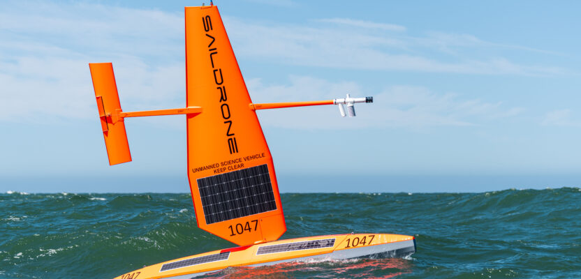
Saildrone brings a fleet of uncrewed surface vehicles designed to make data collection on the sea more cost-effective. Saildrone USVs have already sailed almost one million nautical miles and spent almost 25,000 days at sea.
“We can only realize our goal of a complete map of the ocean floor if we mobilize the international community and work together,” said Jamie McMichael-Phillips, director of Seabed 2030. “The capabilities of Saildrone’s fleet will greatly enhance our ability to obtain essential data and increase our understanding of the ocean, allowing us to make informed and impactful decisions with regard to the future of the planet.”
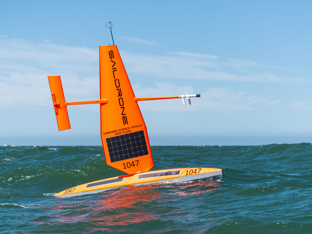 Saildrone’s 65-foot Surveyor-class vehicles are equipped with the Kongsberg EM 304 MkII and Kongsberg EM 2040 multibeam sonars and the AML-6 sound velocity profiler to deliver IHO-compliant bathymetry data to a depth of 33,000 feet (11,000 meters). The 33-foot Voyager-class vehicle carries the Norbit Winghead i80s for near-shore ocean mapping to depths of 900 feet (300 meters).
“Saildrone’s vision is of a healthy ocean and a sustainable planet,” said founder and CEO Richard Jenkins. “A complete map of the ocean floor is fundamental to achieving that vision.”
Most recently, Saildrone Surveyor SD 1200 completed a months-long survey to map more than 17,375 square miles (45,000 square kilometers) around Alaska’s Aleutian Islands and off the coast of California as part of a multi-agency public-private partnership funded by NOAA and the Bureau of Ocean Energy Management (BOEM) to address ocean exploration gaps in remote areas with USVs.
Experiencing 35-knot winds and wave swells more than 16 feet (five meters) in the North Pacific—conditions that likely would have been too challenging for most crewed survey vessels—the Surveyor collected high-quality data without risk to human life and with a reduced carbon footprint. The mission revealed previously unknown features on the ocean floor, including potential hydrothermal vents in Amukta Canyon in the Bering Sea, and a previously unknown seamount standing approximately 3,200 feet (1,000 meters) high off the coast of California.
Saildrone launched its Surveyor SD 1200 in January 2021 and underwent extensive sea trials near San Francisco before its first mission to Hawaii that summer. Some of the mapping performed during that mission was supported by Seabed 2030.
“Autonomous technologies lower the carbon footprint of this effort, using less fuel and fewer resources. We’re hugely excited about what the Saildrone Surveyor is going to deliver for Seabed 2030,” McMichael-Phillips said at the time.
The Nippon Foundation-GEBCO Seabed 2030 Project has also entered into a partnership with ACUA Ocean, which develops zero-carbon emission uncrewed surface vessels. The two parties will work together to accelerate the worldwide effort toward mapping the seabed.
London-based ACUA Ocean is a maritime clean-tech startup working to promote the sustainable economic and environmental management of the ocean. Its hydrogen-powered USV reduces operational CO2 emissions by up to 99.3 percent compared to existing manned solutions, as well as diminishing fueling and maintenance requirements. This enhances operational efficiency by allowing for an increase in range, speed, and endurance. ACUA Ocean also provides offshore asset and conservation protection.
“This partnership with Seabed 2030 is a natural fit for us,” said Neil Tinmouth, CEO of ACUA Ocean. “Our mission is to advance underwater mapping in order to better understand the ocean and its ecosystems. By working with Seabed 2030, we can help to make a significant impact in our efforts to protect the planet.”
McMichael-Phillips said: “Through this new partnership and ACUA Ocean’s innovative technology we can expedite the global endeavor to map the ocean, so that we can better manage it.” ′