Colorado businesses and non-profits teamed to evaluate UAV technology and to network at this fun event.
This spring, a cooperative effort between civil engineering firm CH2M, Juniper Unmanned, the Boy Scouts of America, and local UAS businesses yielded a fun-filled fly-off and network event southeast of Denver, Colorado.
Ground Work and Ground Control
Alexander Mahrou (enterprise geospatial lead at CH2M) organized the event, working with Brian Coleman (sales director for Juniper Unmanned), who in turn coordinated with the Boy Scouts of America (BSA). The Boy Scouts have a 3,500 acre ranch southwest of Denver in Elbert County, Colorado that provided a safe and scenic site for the event.
The team at CH2M, a Denver-area-based civil engineering firm, created the event as a way to evaluate the current state of UAV technology and meet local UAS professionals.
We see this technology as a real game changer, one that many of our clients could benefit from. In addition to being a forum for evaluation, it was a great networking event, as well,
explained Mahrou.
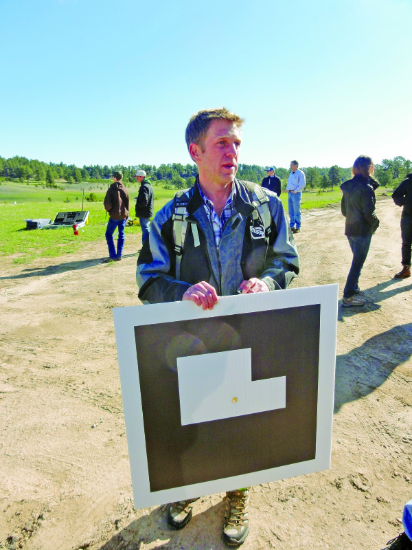
CH2M provided ground control for the two areas of interest, setting monuments and targets for aerial mapping.
Juniper Unmanned flies missions with its fleet of UAS and helps other firms adopt UAS technology for their businesses; Brian Coleman worked closely with the BSA to make sure both parties benefitted from the event. A unique aspect was that, in the return for the use of a part of the facility, the BSA received mapping data, a part of which will be used to determine the true height of berms around the shooting range–data required for standards compliance for the facility.
Coleman shared his view of the event:
Our goal was to provide everyone interested with an opportunity to exhibit the capabilities of their platforms, both from an aeronautical and data collection perspective, in a way that gives them freedom to perform the tasks presented to them while following their own processes and best practices.
Actually, it turned out to be a good thing that we had some adverse weather, because several of the [people flying] platforms considered that a welcome challenge. The other aspect was to process the data in real time and compare the results of the various software platforms, as well as the quality of the data collection itself.
CompassData, a provider of global ground control data, helped design the control layout and provided suggestions for control points and independent test points. Additionally, its team flew its Trimble UX5 and DJI Inspire One.
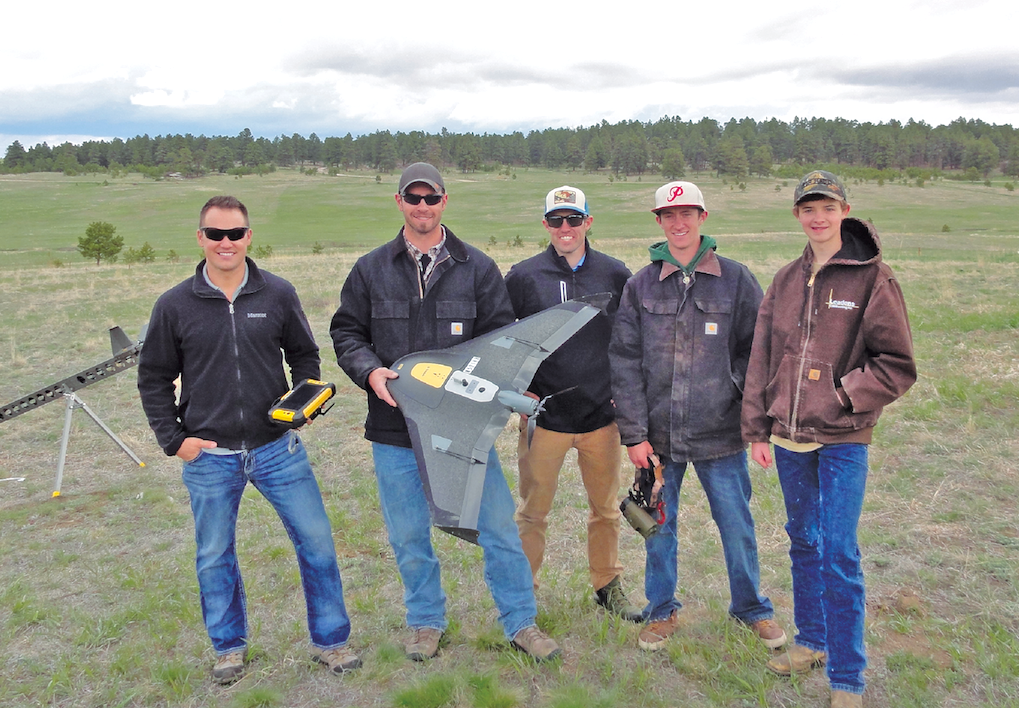
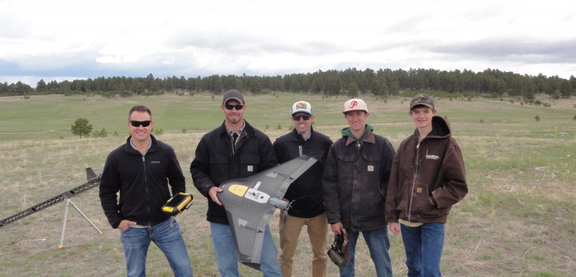
The CompassData team with its Trimble UX5, from left: Justin Lockwood, Mitch Tweedy and Hayden Howard, with high schoolers Patrick Hayne and Wyatt Leadens
Hayden Howard, vice president of CompassData, commented on the event:
Alex Mahrou and CH2M did a great job, and I thought the event was a success! I really enjoyed seeing the mix of geospatial professionals alongside the hardware manufacturers. It’s always good when you get a diverse group of professional who are passionate about what they do together in one place.
DroneMapper, a processor of UAS-derived imagery, was on hand to help process the UAS data and to demonstrate its new geoBits system, an innovative QR-code-inspired ground control target for UAS. geoBits are digitally encoded ground control markers with computer vision software functionality designed to enhance workflows and provide the highest accuracy possible for photogrammetry missions.
Jon-Pierre Stoermer of DroneMapper poses with an example of the firm’s be geoBits QR-code inspired ground control targets.
The initial phase of the geoBit product line is optimized for UAS aerial data collection at elevations of 400 feet and below with 16 unique targets. Jon-Pierre Stoermer, founder of DroneMapper, explained the concept:
Our intention is to prove that with computer vision and the geoBit system, you can get even more accuracy and less human error during the GCP workflow. It also saves a lot of time.
DroneMapper teamed up with CompassData to leverage the event as a test for the geoBits system. CompassData’s Howard explained:
Approximately two weeks before the Fly-Off, Jon-Pierre sent us a link to the geoBits website; I called him up, worked on getting the targets printed, and we made it happen just in time for the event. Since we at CompassData are the ground control experts (aka, ÒThe Control FreaksÓ), Jon-Pierre wanted our feedback and involvement with 6eoBits. We plan to take the geoBit targets and set up some test sites to keep improving the technology.
Jack Elston, PhD, of Black Swift Technologies, was on hand to discuss the firm’s flight control software: Swift Core. Black Swift also offers the Black Swift Trainer, a fixed-wing UAS, as well as a host of UAS ancillary services and assistance to firms with UAS FAA compliance needs.
Esri showed off their new Drone2Map for ArcGIS, which streamlines the creation of professional imagery products from UAS-captured still imagery for visualization and analysis in ArcGIS.
Taking Flight
Once the various flying teams were assembled, Coleman gave a short explanation of the event rules, and the flights began. Two areas of interest were provided: a relatively flat area and the facility’s gun range, a bermed area ideal for aerial volumetric data collection.
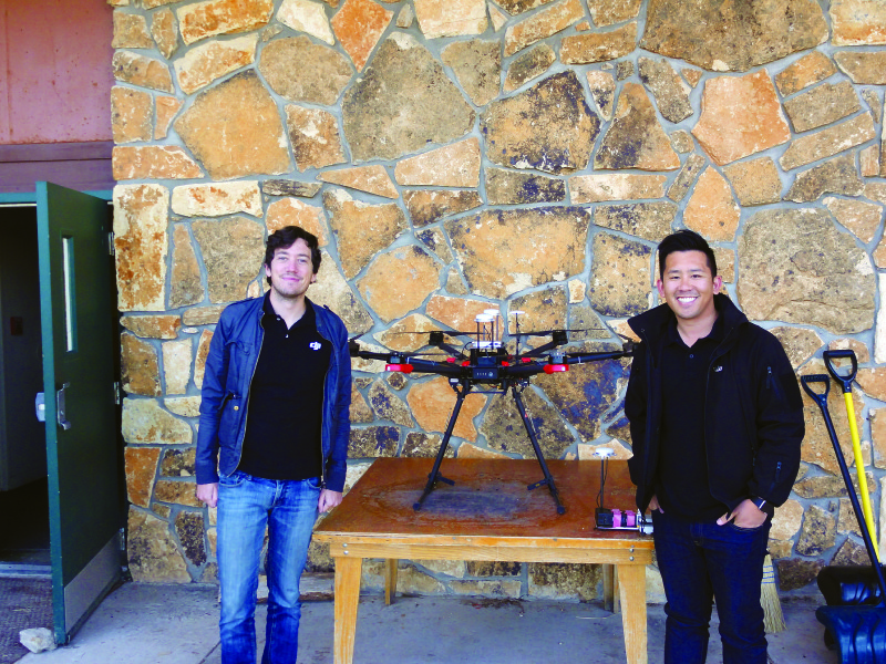
Randall Warnas and Tim Nguyen of DJU with the firm’s new Matrice 600, a professional-grade RTK hexacopter
DJI’s Randall Warnas (business development manager) and Tim Nguyen (business development) were on hand to show off the company’s new Matrice 600, an RTK-enabled professional-grade hexacopter.

Bredan Thomson, and Mary Wohnrade, PE, of Wohnrade Civil Engineers Inc., pose with one of its DJI Inspire 1 quadcopters
Bredan Thompson and Mary Wohnrade, PE, of Wohnrade Civil Engineers, flew two UAS: a fixed-wing UAS, the Black Swift Trainer, and one of the company’s DJI Inspire One quadcopters. The firm uses its UAS largely for its construction work and finds that it can save clients on the average of 50% over conventional techniques.
Wohnrade commented on the event:
The fly-off was a very worthwhile competition, and I hope it becomes an annual event. Even though several companies at the fly-off were competitors, there was a true sense of camaraderie and a strong desire to work together to promote the common goal of advancing the professional UAV industry.
Mel Philbrook of Frontier Precision flew the firm’s Trimble UX5 HP, which integrates a high-performance GNSS receiver and a new Sony a7R camera. The firm provides a wide range of geospatial technology tools, services, and support.
CompassData’s Justin Lockwood, Mitch Tweedy, Hayden Howard, Patrick Hain, and Wyatt Leadens flew a Trimble UX5.
Why not sponsor such an event yourself? If you are a geospatial firm looking to adopt UAS technology, this could be a great opportunity
Rachel Firmin and Blake Scott of Sky Pixel Media flew the firm’s professional-grade DJI S1000 octocopter, which has a maximum takeoff weight of 11 kg (24.2 lbs.) and a three-axis gimbal. The firm focuses largely on aerial cinematography. It’s new to the area of aerial mapping and is investigating the possibilities that the market offers.
Rachel Firmin and Blake Scott of SkyPixel Media, with their professional-grade DJI S1000 octocopter.
Adam Zylka from senseFly came out the following day and flew the course with the eBee RTK. Zylka noted:
The site selection was excellent, and the weather was perfect for me on Thursday! We were able to fly both the AOIs and the volumetrics twiceÑonce each with and without RTK corrections–so it will be interesting to see how this data compares with the other platforms and with itself [standalone with GCPs vs. RTK].
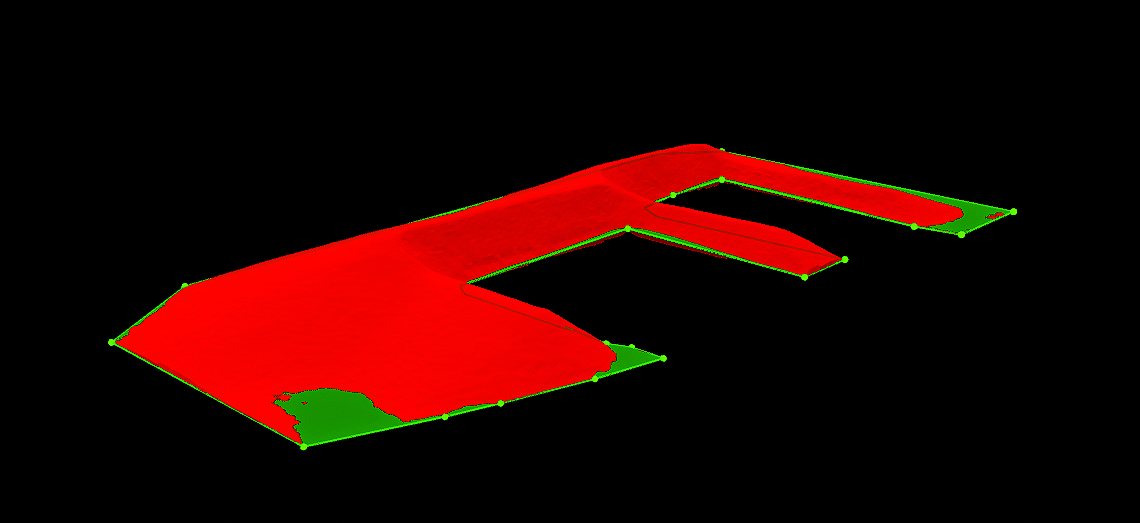
3D volumetric image of shooting range,collected by senseFly’s eBee RTK.
Take-aways
I had a tremendous amount of fun attending this event and found it very interesting. Mind you, I really enjoy attending conferences that focus on UAS technology (and there are more every year). However, the relaxed setting, hands-on viewing of UAS platforms in action, and the networking opportunities made this an especially enjoyable occasion.
It was a great way to pick the brains of practitioners. “What works? What doesn’t? How do you . . .” and so on. If you get the opportunity to attend an event like this, I suggest you take it. Log on to www.Meetup.com and search for events similar to this in your area.
On the other hand, why not sponsor such an event yourself? If you are a geospatial firm looking to adopt UAS technology, this could be a great opportunity for learning, networking, and public relations. You could take a page from CH2M and find someone who could use mapping data in return for use of their land for the event.
Partner with UAS practitioners, not only those flying missions, but those that offer ancillary services such as flight control software and post-processing of UAS data, even manufacturers and/or resellers of unmanned platforms. If you’re a surveying firm, then you can establish ground control, vital to developing accurate data. Invite clients and other interested parties.
End result? You’ll have a lot of fun, and most importantly you’ll learn a lot about this technology before you make significant investments.