In Juniper Flats, CA, county land surveyors use UAS to save tax dollars and project times and to improve public safety.
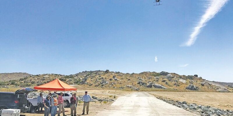
Photo above: Steven Lewis, Trish Ortega, Paul Clements, Claudio Padres of RCFC & WCD; Sebastien Borghini of Microdrones; Dan McMahon of Allen Instruments.
Joshua Tremba does a lot of mapping; he’s the supervising land surveyor for the Riverside County Flood Control and Water Conservation District (RCFC&WCD).
Covering the entire western half of Riverside County, Tremba and the RCFC&WCD are involved in 100 to 200 mapping projects per year. It’s no wonder they began looking for ways to perform this work more efficiently.
Research into new approaches culminated in one conclusion: they needed to consider deploying drones, preferably with direct georeferencing.
“We usually contract the aerial data collection, and it’s often done with traditional aircraft. I wanted to be able to do it much more quickly and easily,” said Tremba. “If there is a flood, large construction project, or anything else we need to map, I want to be able to do it right away and have the data within our possession and control.”
RCFC&WCD is currently working with Allen Instruments, a geospatial equipment provider helping the county learn more about unmanned aerial systems. They sell complete UAS solutions, which include aircraft, sensors, and software: everything surveyors, engineers, and construction pros need to get started with aerial mapping.
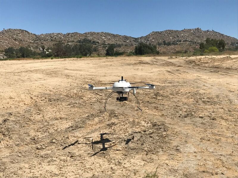
Microdrones’ mdMapper1000DG takes off in Juniper Flats.
While consulting with Allen Instruments, Tremba discovered, “I was extremely impressed with the flight times of the Microdrones systems. They can map large areas with one battery charge.”
What also drew Tremba to mdMapper1000DG was direct georeferencing and the advanced performance it enables.
A Marriage of Convenience
Direct georeferencing (DG) is a method of connecting aerial images to their position on the Earth and putting them together in the most precise possible order. This method drastically reduces the amount of time surveyors like Tremba must spend on mapping projects because it decreases data collection and processing times and eliminates the need to install ground control points (GCPs).
Direct georeferencing drastically reduces the amount of time surveyors must sPend on mapping projects.
“Not having to install GCPs is a really big deal for us,” said Tremba. “It will allow us to complete projects in a fraction of the time. What used to take weeks will now take one or two days. This also amounts to significant cost savings, all while achieving the same or better accuracy. It’s going to revolutionize the way we do our work.”
Testing a UAS to Survey a New Basin in Juniper Flats
The RCFC&WCD describes their mission as follows: “We responsibly manage stormwater in service of safe, sustainable, and livable communities.” Beyond the important goals of improving safety and conserving natural resources, RCFC&WCD’s work also provides tremendous economic benefit to the country.
An example is a high-profile construction project happening right now in Juniper Flats. RCFC&WCD recently tested the mdMapper1000DG on the project, first mapping according to their conventional methods and then using the mapping system with direct georeferencing to compare results.
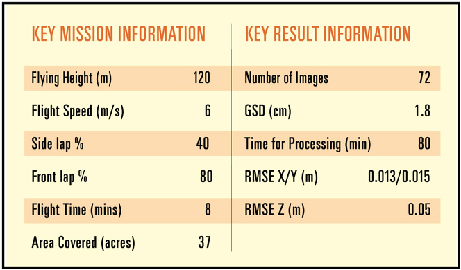
This mission mapped an extremely flat area where a huge basin was recently constructed. The goal was to ensure that the basin would be able to hold the amount of water necessary before it releases into a newly built storm drain system and then eventually into a local river.
Direct Georeferencing Drives Development
The accuracy of this project was crucial. Proper construction of the basin will improve safety first and foremost, but it will also have a huge economic impact on the area.
Developers are planning to build hundreds of homes where there is now mostly farmland in a floodplain. The goal of the basin is to help reduce the area of the floodplain as much as possible to avoid flood insurance requirements for homeowners in those newly developed areas, making these developments more attractive to buyers.
The basin and its down- stream facilities will reduce a whopping 1,882 acres of flood plain to just 70 acres.
“We map over 100 facilities per year, and to achieve that we need to remark and rehabilitate thousands of previously controlled GCPs annually. That is a lot of redundant work that we can now eliminate,” said Tremba. “With the UAS system, we can drastically cut our field time investment while also cutting aerial flight costs. That is incredible.”
This system will also allow surveyors to map more frequently and flexibly. Currently, floodplain maps for an area are made once every ten years.
“At any given time, a map could be up to ten years old. Rather than using these old legacy maps to assess flood risk for large communities, we could just go out with a UAS and get it done, go out immediately and map the area. It will add a lot of flexibility to our operation.”
Dull, Dirty, Dangerous? Not Anymore.
Drones are often said to be great for projects that are “dull, dirty, or dangerous.” Tremba agrees with this statement.
“We have to go into a lot of not-so-fun places to collect data. It’s not uncommon that our employees will need to crawl through poison oak. With a drone, we can avoid that.”
Tremba is convinced UAVs will be right for Riverside, but does the rest of the county agree?
“It takes time for the county, or any government body really, to make decisions about using new technology. But I think once the information is reviewed it will be a no-brainer,” said Tremba. “This system will save our taxpayers a lot of money and help improve public safety. If there’s a flood, we will be able to map it immediately and make important decisions more quickly. It will benefit our community in many ways.”
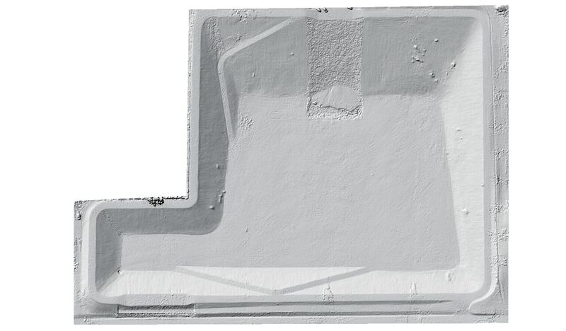
The basin was surveyed two ways: 1) using traditional methods and 10 GCPs and 2) using a UAV and one checkpoint. This test showed strong precision without GCPs using the mdMapper1000DG. RCFC&WCD then compared building plans to the actual completed project to identify areas that were not built to spec and anticipate potential issues. They were also able to produce quick debris and sediment removal maps.