All posts by Gavin Schrock

UAS and ALTA Surveys – Part One
Recognizing that with the right equipment and practices, specifications for ALTA surveys can easily be met, surveyors have rapidly adopted UAS for these and many other types of surveys. The adoption of UAS in the surveying profession has been more rapid than some past tech. It was only 2016 when the FAA Part 107...

An Exemplary Real-Time GNSS Network
For more than 20 years, SWEPOS has consistently demonstrated the full potential of real-time GNSS networks Standing in the main control center of Sweden’s real time GNSS network (RTN) system, I feel like I could be standing in NASA Mission Control. A marvel of infrastructure created by Lantmäteriet, the country’s mapping agency, the center has...
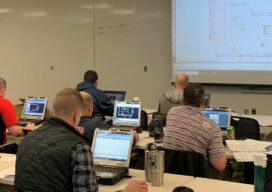
Training as Incentive for Recruitment and Retention
It would be stating the obvious that finding qualified surveying staff right now is challenging. Offering training as recruitment/retention incentive is difficult if such opportunities are limited. A renewed focus on creating more training opportunities, within the profession and supporting industries, is changing this. Training/education as an incentive to recruit and retain survey staff is...

Street-Level Lidar On Demand
As exciting as the advent of on-demand access to current, high-resolution lidar is, so are the tools available for ingesting, extracting features, analyzing, and sharing. “What we’re hearing right now, this is really an inflection point for the industry,” says Phil Christensen, vice president for reality and spatial modeling at Bentley Systems. “The software has...

When a Drone Just Can’t Do It
There is a growing ebb in the tide of UAS adoption for aerial surveying, mapping, and remote sensing—finding the right balance between manned and unmanned aerial operations Unmanned aircraft systems (UAS), remotely piloted aircraft systems (RPAS), or just plain old “drones”—call them whatever you wish—have had a tremendous impact on geospatial industries. A decade ago,...
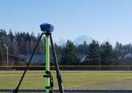
GNSS on Bench Marks?
The GPS on Bench Marks campaign of the National Geodetic Survey is a triumph of constituency participation to improve the nation’s geodetic infrastructure. The initiative is seeing success, but also faces challenges. Multi-constellation support, and acceptance of short RTK/RTN observations, will add a productivity boost. The “GPS on Bench Marks” program of the U.S. National...