All posts by Juan B. Plaza

2022 and the Promise of Expanded UAV Operations
What needs to happen over the next 12 months for the promise of flights beyond visual line of sight (BVLOS) to become a reality? Well, actually, quite a lot. The Federal Aviation Administration (FAA) needs to relax the rules for unmanned aviation and the industry needs to prove that current technology, such as detect and...
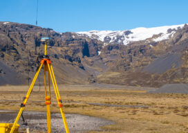
Affordable GNSS: Post-Processing Kinematic in the Cloud
In 1990 I had the privilege to work with a group of pioneers in Canada in the early development of land surveying techniques using a revolutionary new technology known as global positioning system or GPS. Back then, there was only a handful of satellites and the availability of a workable constellation that would allow for...

Riegl Officially Opens New Headquarters
On November 18th and under a persistent Florida drizzle, Dr. Johannes Riegl cut the ribbon that officially opened their new North American headquarters for business. Attended by over 150 people, Dr. Riegl and his son Johannes Riegl Jr., presided over a well-orchestrated and masterfully executed opening gala at the new Winter Garden, FL location. The...
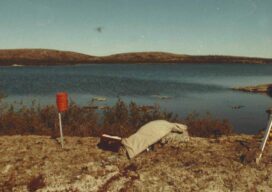
Geospatial Adventure, eh?
Racing the weather to establish a second-order control network in the Great White North in the early days of GPS

Looking Back
Using a single-beam laser to create a mapping profile in the Amazon jungle was a hint at aerial technologies to come

Using Lidar to Strengthen Ground Control
With the maturity of aerial photogrammetry in the early 1900s in pre-war Germany, military applications, especially reconnaissance and semi-accurate 3D maps and approximate contour lines, became the norm.