
Blog

xyHt Weekly News Links: 11/17/17
EdgeTech Introduces New OEM Acoustic Release Components for Customizable Underwater Release Packages Esterline CMC Electronics and NovAtel® partner on new aviation certified GNSS Receiver Hemisphere GNSS Debuts A222 Scalable GNSS Smart Antenna Hemisphere GNSS Announces Atlas® Basic – Instant Global Sub-Meter Positioning for Atlas-Capable Hardware Intuicom Announces Bluetooth BRIDGE™ Engineered Specifically for Autodesk® BIM 360...
xyHt Graphic Tee Shirts
We’re excited to introduce our new graphic tees! Our shirts are printed on high-quality Hanes Tagless 100% ComfortSoft cotton. They are $14.95 each and ship for $4 to U.S. addresses. If you’re ordering from outside the U.S. or purchasing multiple shirts, please indicate that in our order form, and we will work with you to...

Finding Flat Spots: Better Weighing (WIM) for Better Trucking
Laser scanning helps in building and troubleshooting weigh-in-motion stations for commercial trucks. With advances in automated traffic systems and improvements to traffic flows now common along many interstate highways, virtual weigh stations (also known as weigh-in-motion stations, or WIM) for commercial truck traffic are a logical development. This new type of station is an automated...
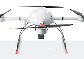
Cool Gear at the Commercial UAV Expo: Part 1
The third Commercial UAV Expo brought together 2,000 professionals from 53 countries and every U.S. state, representing a wide array of industries, all in sunny Las Vegas where the October weather was quite agreeable. The event featured four keynotes, three plenaries, dozens of industry-specific presentations, offsite flying demonstrations, numerous networking events, and more than 150...
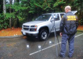
Building a Solid Case: Forensic Mapping (and Ghost Clouds)
A Washington State Patrol officer improves the use of laser scanning for investigations by integrating field and office processes. Rod Green has been doing accident and crime scene reconstructions for 14 years. In addition to collecting and analyzing information, Green is working to improve the reconstruction process on-scene and in the office. His work is drawing...
xyHt Weekly News Links: 11/3/17
Garmin® acquires Navionics® SimActive Automates Direct Georeferencing GeoSLAM Launches Time & Cost Saving 3D Mobile Laser Scanners at Dallas Fall BIM Forum 2017 Singapore International Robo Expo Returns Bigger in 2017: Showcasing Latest Robotics Innovations USDOT launches Drone Integration Pilot Program Velodyne LiDAR and BoE Systems Partner for Integrated UAV-Borne LiDAR in Geospatial Data Collection
Advertisement