
Blog
2022: Monumental Changes, Part 1
The National Geodetic Survey of the U.S. responds to surveyors’ questions on how legacy physical geodetic monuments will be affected by the planned 2022 reference framework modernization. Editor’s note: A recent article in xyHt’s online newsletter, Field Notes, prompted a discussion among surveyors on the pending 2022 modernization of the National Spatial Reference System (NSRS) for...

2022 and You
The year 2022 …. “And then one day you find ten years have got behind you. No one told you when to run; you missed the starting gun.” —Time, by Pink Floyd (Gilmour, Wright) The year of the planned update of the U.S. national spatial reference system, 2022, looms large on the horizon and is...

xyHt Weekly News Links: 12/1/17
Hemisphere GNSS debuts scalable smart antenna Orbit GT releases 3D Mapping Publisher v18 3D Laser Mapping launches campaign to release open-source LiDAR data SimActive Introduces New Technology for True Orthos Marine-i Event creates an exciting vision of the future Applanix and Think 3D Deliver UAV Lidar Mapping with Direct Georeferencing GIS Tools in EDU PR...
xyHt Magazine December 2017 Issue
Click on the cover below to view the December 2017 issue of xyHt magazine. Articles from this issue include: (They appear as links as they go live throughout the month.) 2022 and You (The issue’s editorial) 2022: Monumental Changes, Part 1 The Geodude on the Value of 360° Digital Panoramic Images Maps as Art: The...

Protecting Your Eyesight – at Your Desk
I use special glasses to reduce eye strain in my screen-centric workplace. The geospatial industry has evolved greatly over the last decade, and with the current evolution of our systems this trend shows no sign of slowing down. We are seeing more and more of what has traditionally been considered fieldwork being brought into the...
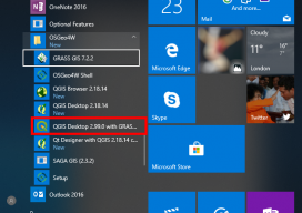
How to Use the New QGIS 3D
When QGIS revealed that they were going to add a 3D viewer, I was skeptical. Rumors were going around about it being a bolt on functionality and not really being fully adopted. To be perfectly honest, I was put off before there was anything to look at. As screenshots started to appear from Lutra Consulting,...
Advertisement