Category Archives: Aerial/UAS
Getting Beyond VLOS
The FAA’s streamlined Section 333 exemption and COA process is welcome, but there’s still a fly in the ointment. While the ongoing FAA Section 333 exemption process is a big step in the right direction for UAS, all operators flying under these exemptions are constrained by the VLOS rule: all flights must be conducted within...
We Are Aviators First
With UAS, surveyors are becoming aviators. As we adopt new technology, we should heed old advice. I flew my first photogrammetric mission in the early 1980s while I was completing my geodesy degree during tumultuous times at my alma mater. While the rest of the world had disco fever, students at Universidad Central de Venezuela...

Copter Power
A UAS rotocopter pilot directs the successful imaging of a breakwater project in Costa Rica. Unmanned aircraft systems (UAS) are finding their way into geospatial applications beyond the obvious commercial topography, volumes, and inspection applications. One particular application that is poised to take advantage of the lower cost associated with UAS data acquisition is environmental...
Trimble Takes Flight with New Multirotor Unmanned Aircraft System
Latest Addition to UAS Portfolio Makes Working in Tight Spaces Easy Trimble announced the ZX5 Multirotor Unmanned Aircraft System (UAS), a new aerial imaging and workflow solution that captures and processes geo-referenced photo and video data for mapping, agriculture and inspection applications. The Trimble® ZX5 complements the UAS portfolio with the ability to reach smaller,...
How FAA Exemptions Work for Commercial Operation of sUAS
How They Work for Commercial Operation of sUAS On February 15, 2015, the Federal Aviation Administration (FAA) published a Notice of Proposed Rulemaking, which proposes to enact part 107 of the Code of Federal Regulations. Specifically, the rulemaking proposes operating requirements to allow small unmanned aircraft systems (sUAS) to operate for non-hobby or non-recreational purposes....
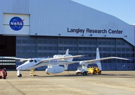
Locata Positioning at Langley Research Center
Locata Positioning will Underpin Future Unmanned Aerial System Research at NASA’s Famed Langley Research Center Locata Corporation announced that NASA plans to install a Locata network (LocataNet) as the core positioning technology for safety-critical unmanned aerial systems (UAS) research at its Langley Research Center in Hampton, Virginia. NASA Langley is tasked with performing rigorous and...