Category Archives: Aerial/UAS
GIS-Ready sUAS
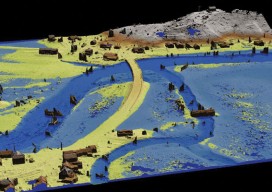
Producing GIS-ready 2D and 3D products to support decisions in transportation. Transportation planners and engineers have often made use of remotely sensed data such as overhead imagery and lidar for mapping, measuring, and monitoring transportation networks. However, despite its utility, remote sensing has failed to achieve its full potential. Remote sensing should be able to...

Robots to the Rescue
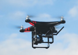
Above: A representative from The German Federal Agency for Technical Relief operates a UAV. The potential for unmanned vehicles conducting search and rescue is proven in Southeastern Europe. Editor’s note: In our January issue we highlighted ways unmanned aerial vehicles are being used worldwide (UAVs for the Whole World), including for conservation, at high altitudes, and...
EagleView
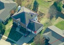
The practical side of on-demand aerial image analytics, with an interview of CEO and president Chris Barrow. A contractor showed up at my house to give an estimate for a long overdue roof replacement. He hadn’t pulled out a ladder, so I asked if he needed mine. His response was, “Since we started using EagleView,...
MAPPS Comments on Developing Best Practices for Use of UAS
The National Telecommunications and Information Administration (NTIA) has called for comments on UAS and privacy; their request is here:NTIA seeks comment on the process for developing best practices for commercial and private use of unmanned aircraft systems MAPPS has filed its comments, which you can find below: Formed in 1982, MAPPS (www.mapps.org) is the only...

Maximizing the Sun
Solar energy grows in part due to aerial imaging and surveying. Solar power is booming in the United States. “Every three weeks,” President Obama said in his 2015 State of the Union address, “we bring online as much solar power as we did in all of 2008.” Geospatial technologies—especially remote sensing and surveying—play an important...

xyHt Heights 2015
Click here to view Heights 2015