Category Archives: Aerial/UAS
ASPRS Engages States
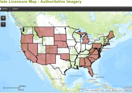
Above: State Licensure Map – Authoritative Imagery ASPRS Launches New Initiative to Engage States as They Consider Regulating Photogrammetry under Existing Surveying Laws At the American Society for Photogrammetry and Remote Sensing’s (ASPRS) November 2014 fall conference in Denver, Colorado, ASPRS announced its “Licensure Plan for the State Licensing of Photogrammetrists” initiative. ASPRS recognizes an immediate...

Working For You
Interviews with representatives from ASPRS, AUVSI, SPAR Point Group, MAPPS, and PAPA Several groups have evolved over the years to represent geospatial organizations that use aerial platforms in the course of their work. We asked five of these organizations (with a combined membership in the tens of thousands) the following questions: What do you do...

Keeping the Dream Alive
Above: Valley Air Photo’s full lineup: the single-engine Beechcraft V35 Bonanza is their main film aircraft; the twin-engine Cessna 320s are capable of carrying both film and digital cameras but are mainly used in digital acquisition. At its 30-year anniversary, a small aerial photography business recounts changes in the industry and in itself. Thirty years...
UAS Coalitions
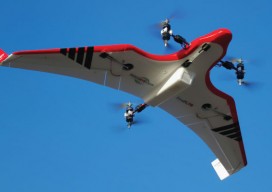
Above: Hybrid multirotors such as the FireFly 6 are offering solutions to common problems, allowing automated takeoff and landing along with waypoint flight control. Credit: Jon Barnes, Bajora Media. What are they doing for the UAS industry? Being an entrepreneur is a lot like being a surfer. You need a surfboard and access to...

Surrogate UAS
Above: Hart Drobish, president of Courtney Aviation, was a contractor to the forest service flying the air tactical control platforms on the Happy Camp Complex wildfire. Additionally, Drobish served as a ground liaison contact on the project, managing the flow of infrared and visual imagery from the aircraft to the end users. Combining UAV technology...
Lidar for Forestry
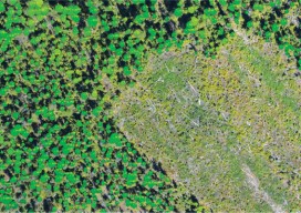
Above: Lidar-derived tree crowns and maximum tree-top heights are overlaid on a 20cm orthophoto. Vector-based products allow for a transition from the point cloud to GIS. A forester’s guide to understanding lidar topics, from upfront data-acquisition costs to business benefits to the path from research to operationalization. Although many lidar industry insiders never imagined the...