Category Archives: Civil/Transportation

The Wide World of Drone Upstarts
With congested airspace in the U.S. and Europe, to see how drones will integrate with society we have to look at some creative drone upstarts emerging in less populated nations. In our last article we touched on the ramifications of a clear regulation of uncrewed flights beyond visual line of sight (BVLOS) in the USA and...

Upgrading GIS for a Better 911
The complex system of emergency call routing and critical location data delivery is getting a makeover Minutes can make a difference between life and death for 911 callers. A quick response with suitable equipment and knowledgeable personnel is the goal of 911 call centers across the country. However, managing calls and texts from mobile phones...

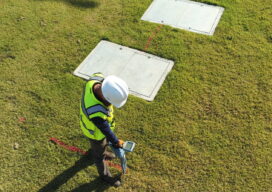
Geospatial Services for Transportation & Utilities
GPI Geospatial, Inc. has been a premier provider of geospatial solutions for over 48 years. Our mission is to map the foundation for infrastructure, transportation, and land improvements that enhance the connectivity between people and communities. It’s our vision to be the most trusted provider of precision mapping, imagery, LiDAR, and surveying services within the...

Woolpert Blends Methodology with Technology
What began as a four-person engineering and survey company in Ohio in 1911 has steadily evolved to become a full-service architecture, engineering, geospatial (AEG), and strategic consulting firm, with more than 1,600 staff and 60 offices on four continents. This fusion of AEG data breeds innovative products and solutions that address complex challenges worldwide, providing...

Sometimes It’s What They Don’t Say
When you’re trying to get something accomplished, it’s always disappointing to come up against that person who wants to disagree vehemently and debate the subject at hand. Sometimes when a surveyor is performing his duties to recover property boundary evidence in the field, the owner of an adjoining property may come along and try to...
3D Models Above and Below
Aerial, terrestrial, and underground data tell the whole story Millions of miles of underground utilities provide U.S. communities with vital services, such as telecommunications, water, electricity, and natural gas. During construction projects, accidental damage occurs frequently due to inaccurate or non-existent documentation, a situation that can be exacerbated by inadequate research before excavation begins. Safety...