Category Archives: Energy/Utilities

Alex Lopez-Rogina
23 Young Geospatial Professionals to Watch in 2023 – 22 of 23 Name: Alex Lopez-RoginaCompany: Avineon, Inc.Current position: GIS Project ManagerAge: 32 Education: BS in Civil Engineering, University of Alabama-Huntsville; GIS Certificate, University of North Alabama Lopez-Rogina started her professional career as a civil engineer for a water utility in northern Alabama. When the company...
James Richards
23 Young Geospatial Professionals to Watch in 2023 – 7 of 23 Name: James RichardsCompany: Benchmark SurveysCurrent Position: Survey Manager–Land, Utility and Measured Building SurveyorAge: 29 Education: Level 3 Surveying Technologies Theory; Level 3 Utility Mapping and Surveying Biography: Richards came out of school chasing the dream of becoming a professional footballer. He signed a...
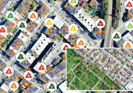
In the Red
Thermal imagery helps reveal building heat loss Dr. Geoffrey Hay envisioned a solution for an invisible problem in a few milliseconds. Hay, a GIScience professor at the University of Calgary in Alberta, Canada, was perplexed by his higher-than-expected heat bills after moving into his new, modern home that was equipped with “energy-efficient everything.” It was...

URISA Announces 2022 Digital Competition Results
URISA’s Vanguard Cabinet is pleased to announce the results of the 2022 Student and Young Professional Digital Competition. Eligible participants were currently enrolled in a college or university, a recent graduate, or a young or emerging geospatial professional with fewer than five years of experience. The competition was limited to projects that utilize web and mobile platforms, such...

Virtual Cities Are Rising
Cutting-edge 3D city models lead the way to better urban planning via digital simulation Take a peek at Helsinki’s virtual 3D city model and what might at first seem to be just rows of solid objects soon reveal themselves as handsome blocks of buildings that line gridiron streets. This is the digital doppelganger of Finland’s...
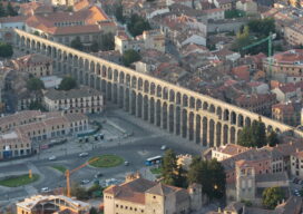
The Challenge of Channeling Water
From the Romans to the Everglades, the art of directing water flow has never been easy For thousands of years impromptu land surveyors tried, sometimes successfully, to force water to flow in a direction it did not want to go. This was done to help grow crops in areas where water was not abundant enough...