
Part 1 of 2
The new version of the NGS suite of Online Position User Service tools simplifies many tasks
By Philippe Hensel
With Dan Gillins, Dan Martin and Julie Prusky
NOAA’s National Geodetic Survey (NGS) continues to improve its suite of Online Position User Service (OPUS) tools. In addition to single-point processing, OPUS offers a web-based utility known as OPUS Projects with the tools to organize, process, and adjust campaign-style surveys to the National Spatial Reference System (NSRS, Figure 1). It automatically aligns data with the latest realization of NAD 83 and NAVD 88 (or other local vertical network).
“Using OPUS Projects is a great way to process, manage, and share high-quality geodetic control with the geospatial community,” says Kevin Maxwell, chief of GNSS and geodetic control for the California Department of Transportation land survey office. “It can reduce time spent researching by having data in a nationally maintained, recognized, and accessible online location. We recommend its use whenever geodetic control is involved in a project.”
It’s all about Geodetic Control
Single OPUS-Static (or Rapid-Static) solutions submitted to the OPUS upload page (Figure 2) are fine if you need to check your survey control or create positions that are relative to the NSRS. But if you need to establish geodetic control, meaning establishing authoritative positions and heights with known network and relative (local) accuracies, then you need more than just a check. You need OPUS Projects.
OPUS Projects also provides an easy way to submit your campaign data to NGS for inclusion in the Integrated Database (IDB). By doing so, not only are you providing authoritative coordinates with estimated relative and network accuracies published on NGS Datasheets, but you are contributing to the improvement of NGS models and tools you rely on.
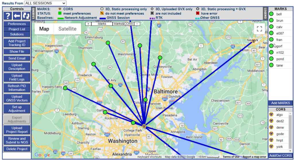
Figure 1: Example of a project shown on the OPUS-Projects Manager’s Page after all observation sessions have been processed.
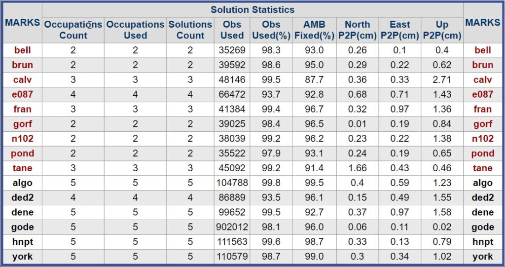
Figure 2: Solution statistics from a sample OPUS-Projects project, providing percent observations used in the solution, the percent ambiguities fixed, and “peak-to-peak” error estimates (among other statistics).
Relative (Local) Accuracy
OPUS Projects will provide you with robust estimates of relative accuracy as a result of constrained least-squares adjustment of GPS-derived baselines between Continuously Operating GNSS Reference Stations (CORSs) and user-observed marks in a survey network. It processes all of the baselines simultaneously, accounting for all correlations in the observations from the satellites at the time of the survey. Not only does this help remove common mode errors, but those correlations provide the estimates of relative accuracy.
NAVD 88
If heights in your local vertical datum (NAVD 88 for the continental U.S.) are important to your survey, by tying and constraining directly to bench marks and other high-precision orthometric heights, OPUS Projects can produce heights with high relative accuracies. Since the origin of “Height Modernization” surveys in the 1990s, NGS has supported the use of GPS-derived orthometric heights to densify the NAVD 88 network. The user is directed to the OPUS Projects User Guide for more information. Other vertical datums supported include PRVD02, NMVD03, GUVD04, VIVD09, and local (tidal) datums.
Alignment to the NSRS
OPUS Projects ensures your entire survey control network is tied consistently and accurately, both internally and externally, to the NSRS. As with all OPUS products, you are ensured that your solutions are using the very latest hybrid geoid model, the latest Horizontal Time-Dependent Positioning (HTDP) model, and are referenced to the correct State Plane Coordinate System (SPCS). Many Real-Time Network (RTN) Managers are using OPUS Projects to align their networks to the NSRS. Similarly, local surveyors can use OPUS Projects to align their survey control to the NSRS easily and simply using its intuitive, user-friendly interface.
Publishing Your Data
If your work requires you to set authoritative geodetic control using GPS, then look no further than OPUS Projects. In its latest version (currently OPUS Projects 5), users are able to follow a tried-and-true sequence of geometric and vertical adjustments, bringing their network in alignment with the latest realization of NAD 83 and NAVD 88 (and other vertical datums: PRVD02, GUVD04, VIVD09, etc.). Users can easily upload their survey mark description files, scanned field log sheets, digital photographs, and a digital final report, and with the click of a button, submit their entire project to NGS for review. Upon successful review, new or updated datasheets for the survey marks will be published on NGS datasheets, establishing authoritative geodetic control where you need it. Data that you submit will be used by NGS to help develop models and tools, and provide valuable geodetic control thereby expanding and validating NSRS stations.
RTK Data
A new enhancement is also available in OPUS Projects 5, which allows users to upload their Real-Time Kinematic (RTK) vectors into their project. This advanced capability is made possible using the new GNSS Vector Exchange (GVX) file format. Users can now reap the benefits of adding RTK vectors with their static GNSS occupations in a least-squares solution. This new capability will support submission of the entire project to NGS for review, and the potential for the efficient creation and updating of official geodetic control.
It’s Simple and Easy
OPUS-Projects provides very intuitive data organization and visualizations, but it also incorporates a number of very useful features:
- CORSs that were used in the individual OPUS-S solutions are automatically included in the project. You can also easily select other CORSs, screening them by their performance characteristics. OPUS Projects computes positions simultaneously on not only your observed survey marks, but also on the CORSs. By comparing computed positions to the CORSs’ published positions, you can quickly see if there are disagreements with either your own survey control or possibly even with the behavior of a particular CORS on the day of observation.
- OPUS Projects pre-selects the NGS-recommended “hub-and-spoke” design for your network, picking the most central CORS within your project as the hub, with spokes radiating out. Of course, the user can specify any number of other network designs.
- OPUS Projects guides you through a sequential set of five least squares network adjustments, providing the necessary information to validate the results of your survey. Each step of the way, OPUS Projects recommends the necessary constraints. If you have uploaded a description file to the project containing survey marks with published NGS Datasheets, OPUS Projects will use the official positions and/or heights in the project.
- OPUS Projects vastly simplifies the process of submitting a GPS survey to NGS for publication. The entire process of “bluebooking” is now behind the scenes, and all the user has to do is follow the sequential steps of network adjustments and upload the supporting files.
 Professional Results
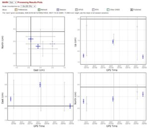
OPUS Projects provides a broad palette of results. For many users, the graphic visualizations and tables provided within the OPUS Projects web interface will be a good starting point for further analysis. Figure 3 shows part of more detailed analysis of processing results for a particular user mark (assigned the four-character ID “fran”).
For the user interested in submitting the project to NGS for review and publication, a number of output files are available for review. These output files are available from within OPUS Projects (by clicking on the “Show Files” button), as well as within the email attachments automatically sent to the project manager.
The Processing Report contains the all-important shifts from published control that the user will want to scrutinize.
Resources
Currently, to gain access to OPUS Projects, an instructor-led class is required (in-person or online). A schedule of upcoming classes is available on the NGS Testing and Training Center’s calendar. Very soon, NGS will provide self-paced training tutorials, which will remove this requirement. Additional resources include training videos and a comprehensive OPUS Projects User Guide to support both novice and advanced users.
The document begins with a Quick Start guide for users already familiar with the software. For those less familiar, the rest of the 200-plus page manual gently guides the reader through all phases to help ensure a successful project, from project design, the submission of a project proposal to NGS, to CORS selection, session processing, and network solutions.
Conclusion
If you are running a GPS survey, and high relative accuracy, alignment of your network to the NSRS, including NAVD 88, and the establishment of official geodetic survey control are important to you, consider using OPUS Projects. OPUS Projects is easy to use and has a wide array of intuitive and graphical output, as well as in-depth results. The latest version has simplified many tasks, especially if you are interested in submitting your project to NGS for review and publication.
Philippe Hensel is the supervisory geodesist with NOAA’s National Geodetic Survey and project analysis branch chief. Dan Gillins is an NGS geodesist. Dan Martin is Northeast Regional Geodetic Advisor for NGS. Julie Prusky is an NGS geodesist.