Category Archives: GNSS/Location Tech

Geospatial Adventure: Ghost Towns and Diamond Mine Memories
Diamond mine memories: A century or so ago, miners in the small settlement of Pomona pulled 50,000 carats of diamonds a month from the vast, arid nothingness of land called the Sperrgebiet—10,000 square miles of coastal desert in southwestern Namibia in Africa. The sandy ground has long since given up the last of its precious...

Daenerys; Dothraki; Dubrovnik: How 3D Scanning Built a Game of Clones
How lidar imaging turned Dubrovnik Old Town, Croatia, into a realistic fantasy world! The sight of King’s Landing, the capital and largest city of the Seven Kingdoms, is spectacular. The population found within verges on half a million but from a bird’s eye view, it is serene and calm, with the gentle sounds of Blackwater Bay in the...

Doers: Christoph Hinte
Christoph Hinte on 25 years at Intergeo Christoph Hinte is the organizer of INTERGEO, the world’s biggest annual geospatial trade fair and conference. As CEO of HINTE Expo & Conference, he has been involved in the development and strategy of INTERGEO events since in 1995. Hinte tells xyHt why this year’s event, October 13 to...

Jack Dangermond Interview Part 1: The Company
At the Esri User Conference, xyHt European editor Nicholas Duggan sat down for a one-on-one interview with Jack Dangermond, Esri founder and CEO. In Duggan’s five-part online series, running each day this week, Dangermond discusses everything from Esri’s beginning to the future of GIS. Here in Part 1 the two discuss Dangermond’s company. Nicholas Duggan:...

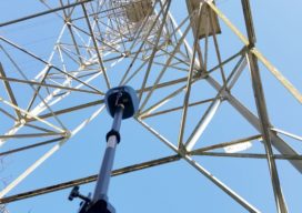
Trimble R12i: The Next Evolution of GNSS Solution
The new Trimble R12i GNSS receiver marks the latest addition to its Global Navigation Satellite System (GNSS) portfolio. The Trimble R12i incorporates robust tilt compensation to increase productivity for land surveyors. The Trimble R12i incorporates Inertial Measurement Unit (IMU)-based tilt compensation using Trimble TIP™ technology, which enables points to be measured or staked out while...
What is Tersus GNSS?
I had seen the name Tersus GNSS in geospatial social media for several years before our xyHt team stopped by their booth at the INTERGEO exhibition in Berlin in 2017. For a startup, launching in 2014, the company appeared to be making a lot of the right moves. As high precision GNSS was entering what...