Category Archives: Hydro/Marine
Michelle Japitana
Instructor and Concurrent Chairman, Engineering Sciences Department, Carga State University, Philippines Testimonials for Michelle Japitana were remarkable. (This year we received a record number of nominations from the Philippines, and we wish we could honor all the fine candidates.) Michelle’s nominators noted that her strength in the geospatial community is her research capabilities in the fields...
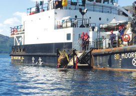
Recovering the Bouncing Bombs
Sidescan sonar helps a hydro survey team and a dive club find and raise the famous bouncing bombs from WWII. (Above: The SD Moorfowl lifts a Highball from Loch Striven.) As of May of 2018, it will be 75 years since the famous German dam buster raid by the Royal Air Force. The raid used...

Yaw, Pitch, and Roll
Nautical lidar works for a waterway bridge replacement project in Boston. Waterway projects can pose major challenges for surveyors and engineers needing survey-grade data because of unpredictable variables in the marine environment. Surveyors face inaccessible areas, tidal changes, marine traffic, and unpredictable weather, as a few examples. The Massachusets department of transportation (MassDOT) undertook an...

Night in the Afternoon: A US Solar Eclipse
What you need to know about the 2017 solar eclipse The upcoming solar eclipse will leave a 70-mile-wide trail of darkness across the United States on August 21, 2017 (see the map of the eclipse path on pages 44-45). This will be a once-in-a-lifetime event for many people. While another total solar eclipse will make...
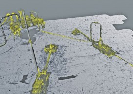
Surveying a Mile Down
Above: The metrology viewed as a combined model. A 3D surveying company provides highly detailed lidar data on subsea drill centers. This article almost didn’t happen. I first met with ADUS DeepOcean in January 2017, when we discussed how they had captured high-resolution laser data deep in the ocean off Ghana. Today, four months later, I...
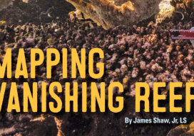
The Hydrous: Mapping Vanishing Reefs
Using geospatial technologies, The Hydrous provides “open access” to oceans in an attempt to save critical habitats. The oceans of the world are vital to our survival. While monitoring their health is the realm of scientists and protecting their health is the responsibility of everyone, few of us truly experience the richness of these aquatic...