Category Archives: Hydro/Marine
Our Changing Oceans and Coasts
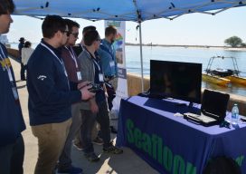
Students watch a pier demonstration—back row, l to r: Clayton Harbin, Troy Peterson, Max Crowe, and Jack Jamieson from NW Michigan College and Casey O’Heran from University of New Hampshire. In front is JT. Myers, an ocean engineer at Seafloor Systems. Highlights from the U.S. Hydro 2019 Conference The U.S. HYDRO 2019 Hydrographic Society of...

Ocean Business 2019
With preliminary surveys already starting around the coast of the UK for another round of wind farms being built, the offshore industry descended on the National Oceanographic Centre in Southampton, UK for the bi-annual event, Ocean Business, centered around the offshore survey industry. Luckily, my home is a walk away from the event, so I was more than happy...
Emily Tidey
Lecturer, Hydrographic Surveying, Otago University Dunedin, New Zealand We received a record number of nominations for geospatial professionals in New Zealand this year—and all were women! While difficult to choose from among the candidates, Emily Tidey stands out as an educator and specialist in the essential (but often overlooked) surveying discipline of hydrographic survey. Maritime...
Emilie Novaczek
PhD Candidate, Marine Geomatics Research Lab, Memorial University Newfoundland & Labrador Canada While still at the beginning of her career, Emilie Novaczek has already gained the attention of the marine mapping and research community as well as acclaim for her work in related youth education, volunteer coordination, and mentorship. And Novaczek does a lot of...
Street Views of the Water
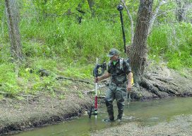
Above: Martin Offenhauer surveys the Big Rock Road section of the San Diego River. Credit: SDRPF. Mapping rivers above and below the surface creates great opportunity for engineers and stewards. The way maps are produced and displayed varies greatly, depending on their extent, their intended use, and the peculiar challenges of each environment. Mapping a...
After the Storm
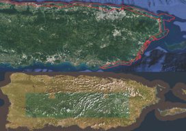
Above image: Puerto Rico was surveyed using the Coastal Zone Mapping and Imaging Lidar system to provide efficient damage assessment. Image courtesy of the Joint Airborne Technical Center of Expertise. Post-hurricane coastal mapping is a complex process made easier with airborne bathymetry. Lately, large storms such as hurricanes, cyclones, and typhoons have been wreaking havoc...