Category Archives: Surveying

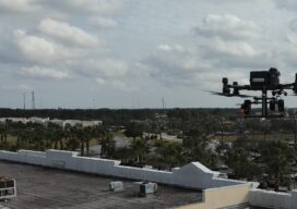
Sky High
UAVs deliver practical and highly technical mobile mapping Collecting imagery with uncrewed aerial vehicles (UAVs) is ideal for a variety of applications including topographic mapping, forestry ground and canopy measurements, powerline corridor mapping, Digital Terrain Model (DTM) generation, high-resolution digital imagery, and orthophoto production, along with support for a variety of other mapping needs. Historically,...
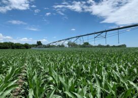
Farming From Space
Airbus and Sentinel Fertigation use satellite imagery to improve sustainable crop production With help from Airbus’ detailed high-resolution 30cm satellite imagery provided by Pléiades Neo, a Midwest crop management software platform is offering a streamlined process for farmers fertilizing crops via irrigation (known as fertigation). Using multispectral imagery of field conditions, Lincoln, Nebraska-based Sentinel Fertigation...
Celebrating the 50th Anniversary of the Brooks Act
By John Palatiello On this day, October 27, in 1972, President Nixon signed into law legislation providing for qualifications based selection (QBS) of architecture, engineering, (A&E) and related services, including surveying and mapping. It was 50 years ago today the Brooks Act became law. At the time of its enactment, the Brooks Act was a...
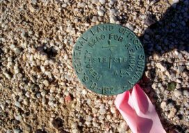
Legal Boundaries: Monuments and Corners
Is there a difference between a monument and a corner? Many surveyors use these two terms interchangeably as if they were synonymous. Technically speaking they are not the same, but in many instances a monument will be the physical manifestation of the true corner location. This is the ultimate surveying question, is that monument actually...
UAS and ALTA Surveys – Part Two
Surveying firms that have been successful in incorporating UAS data in ALTA surveys adopt best practices to ensure precision standards are met. Plan, execute, and check. In Part One of this three-part series in the September xyHt issue, we looked at the time/cost/precision proposition of using UAS for elements of ALTA surveys. Firms interviewed agreed...
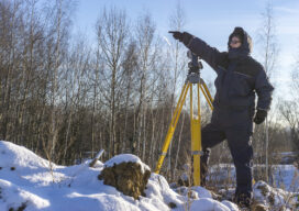
It Can Get Uncomfortable Out There
Most field surveyors are pretty tough. This is somewhat contrary to what I had written in a previous article which posed the question, “Are Surveyors Getting Soft These Days?” That can be debated, but I truly believe that my first sentence is true. When the temperature gets above 90 degrees, as it does in many...