Category Archives: Surveying
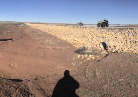
Surveyors Saving the Wild Pecos River from Itself
Survey helps protect land and wildlife from New Mexico river flooding “Well we can make it to the road in a homemade boat Because that’s the only thing we got left that’ll float It’s already over the wheat and the oats Two feet high and rising’” —Five Feet High and Rising by Johnny Cash If...
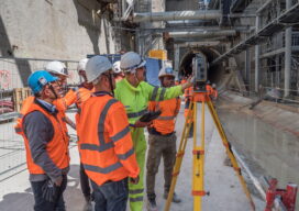
Grand Surveying in Grand Paris
Advanced solutions for tunneling and monitoring keep Europe’s largest transportation expansion project on track All photos taken prior to introduction of COVID-19 distancing guidelines Paris is grand—and getting much grander. One of the most visited—and loved—cities in the world, The City of Light began the Grand Paris initiative in 2007 with the goal of keeping...

InfraMarker on Display at Esri Infrastructure Conference
Berntsen International, the leader in infrastructure marking solutions, has partnered with CHA Integrated Solutions (formerly NovaraGeo Solutions) to provide its InfraMarker RFID capability within the Corrivo mobile software platform, delivering Traceable, Verifiable and Complete (TVC) field asset data. See it at the Esri Infrastructure Management & GIS Conference on October 29. CHA Integrated Solutions will...

As-Built Documentation with Speed and Accuracy
Most architects, designers and engineers are aware of reality capture technology and laser scanning but might not be sure how it could fit into their workflow, especially when it comes to as-built documentation. To get a better sense of how this technology works with as-built documentation, let’s first recap what reality capture means in the...

A whole new approach, by any measure
Topcon provides a next generation of products designed to make you more productive and fill the need of a more connected approach to projects.

Jack Dangermond Part 5: Looking to the future
At the Esri User Conference, xyHt European editor Nicholas Duggan sat down for a one-on-one interview with Jack Dangermond, Esri founder and CEO. In Duggan’s five-part online series, running each day this week, Dangermond discusses everything from Esri’s beginning to the future of GIS. Here in Part 5 the two discuss what might be coming...