By definition, close-range photogrammetry (CRP) is simply photogrammetric data collection and processing where the subject is less than 1,000 feet away. Collection methods can be both ground- or aerial-based, and the final output can be rendered either two- or three-dimensionally.
Several factors have made this a powerful tool for geospatial professionals. The strongest of these is the recent advent of 3D photogrammetry, often referred to as “multi-ray photogrammetry”: a technique that takes overlapping, stereo-paired photographs and turns them into 3D point clouds. These point clouds can then be processed through the same software used for 3D scanning. Autodesk’s ReCap is an example of this software.
Another factor for increased interest and use of CRP is the expanded use of UAS; the overwhelming majority of UAS projects rely solely on CRP. Since this technology can use reasonably priced off-the-shelf digital cameras, 3D photogrammetry yields a significant reduction in hardware costs compared to 3D laser scanning. Additionally, standard digital cameras are both smaller and lighter than typical 3D scanners, making them ideal for incorporation into UAS platforms.
Applications for this technology abound. Beyond UAS aerial mapping, the mining industry is taking advantage of CRP. Volumetric mine site analysis is an example of where CRP can provide a fast and cost-effective solution. Rockfall mitigation is another application. Essentially, any application that does not require the ultra-precision of laser scanning can be a candidate for CRP technology.
Recently CRP, especially as it pertains to 3D photogrammetry, has seen interest from tech-heavyweight Google with their Tango project. Still in development, Tango incorporates conventional, depth-sensing (similar to MS Kinect) and motion-sensing cameras into an Android smartphone. The result will be a smartphone capable of collecting 3D data and producing 3D imagery. (See one researcher’s view on what happened to Tango here.) Two partners in Tango, Matterport and Paracosm, have already launched products using this technology. While these devices do not approach the functionality and accuracy of state-of-the-art laser-based scanners, they can be useful for visualization projects and give us a glimpse of where this technology is headed.
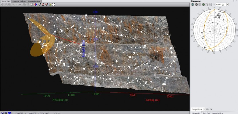
Image: This screen capture of Sirovision shows a stability analysis feature used to determine areas of instability for rockfall hazard analysis—courtesy of CAE Mining.