Land surveyors are taught the requirements of an effective land description, but the plat map or exhibit that frequently accompanies a land description is often a neglected topic of discussion. In this article I discuss how to create superior land description plats. I begin with a simple definition of a land description plat, follow with an understanding of the plat’s purpose, list the challenges of creating an effective plat, and conclude by considering the important elements of a land description plat.
What Is a Land Description Plat?
We need a simple definition of a land description plat to aid in the understanding of this article. Here is the definition that I prefer:
A map that graphically depicts the boundaries of a parcel of land. The plat is typically printed on a small size and accompanies a written land description of the same parcel it depicts graphically.
Most boundary surveyors are very familiar with land description plats. They’ve used them to understand and retrace land description boundaries, or they’ve created plats for their own land description packages.
Its Purpose
 Why do boundary surveyors create land description plats? What is their purpose?
Imagine trying to convey all of the information needed to construct a large sports stadium using only a written document. This would be a great challenge. We use graphical plans, or blueprints, of construction projects because the information is ideally suited through communication by graphical means. In many cases, our human brains more readily understand information presented as pictures than we do information presented with words.
The same principle applies to our description of land parcels. Although the written description of a land parcel’s boundaries is important, the description is often easier to mentally digest and understand in a picture format. This is especially true for the non-surveyor who may struggle to understand the traditional written land description. Plats can be used to visually convey important aspects of the subject land parcel that are difficult to quickly grasp from a written description.
These aspects include:
- the shape of the parcel,
- the size of the parcel,
- the relationship between the subject parcel boundary and the boundaries of surrounding parcels,
- the relationship between the subject parcel boundary and important geographic features or controlling elements, and
- the relationship between the parcel boundary and controlling property corner monuments.
Who Is the Typical Audience?
The first category in our typical audience is our fellow boundary surveyor. This is the person who most closely examines our plat and the most important user of the information that it contains. The data shown on our plat can be used by our fellow boundary surveyor to actually determine the location of land parcel boundaries on the ground. For this reason, our fellow boundary surveyor is the most important viewer of our plats and should be the person we keep first in mind when we design and draw our plat.
The second category in our typical audience is a land professional without a land surveying background. This could be a land attorney, a land title officer, a land manager, or someone from the planning department at a local government agency. Because of their limited land surveying background, these individuals will often rely more heavily on the plat than the written land description.
For these land professionals, the plat is the primary vehicle for conveying information about the subject land parcel boundary. For this audience, the boundary surveyor must remember the plat he designs and draws may be the only part of the land description viewed and used. It must therefore, to the extent possible, stand on its own, independent of the written description.
Challenges
We’ve all looked at ugly survey maps or survey maps that are confusing and difficult to understand. Because of the unique challenges presented by the format, it is even easier for a boundary surveyor to create an ugly or confusing land description plat. The legal weight that can be given to a plat in the United States legal system can make a confusing land description plat more harmful than no plat at all.
What are the challenges of the typical land description plat format?
- They are typically drawn on a small-sheet size. This is often 8.5 inches by 11 inches with a 1-inch margin.
- They are typically drawn in black and white, with very limited ability to represent shades of gray or screened shades.
- There is usually a minimum text size of 0.10 of an inch.
What are the implications of these challenges?
- If you have a large parcel or a parcel with a complex boundary, the small-sheet size can make it difficult to properly convey information on the parcel boundary at a suitable scale.
- The color and shade limitations can make it difficult to establish a visual hierarchy to represent the importance of information shown on the plat.
How Do You Overcome These Challenges?
The first challenge of small sheet size can be overcome by the proper use of details and multi-sheet layouts for your plat.
The second and third challenges can be overcome by the effective use of fonts, line types, and line weights.
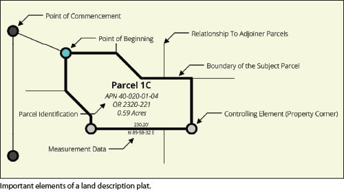
The Important Elements of an Effective Land Description Plat
What are the important elements that should be included in every superior land description plat?These elements include:
- the boundary of the subject parcel,
- the measurement data for the subject parcel boundary,
- the identification and location of controlling elements that help define the subject parcel boundary,
- the identification and location of the land description’s point of beginning,
- the identification and location of the land description’s commencement points,
- the relationship between the subject parcel and the surrounding parcels, and
- identification and ownership information related to the subject parcel. This would include the parcel name, owner name, tax assessor identifier, physical street address, and identification of the vesting deed.
In a future article I consider how the information in this article can be applied. I also consider a couple of example land descriptions and discuss how effective land description plats can be created for them.