An industry insider provides an overview of the advantages of using UAS for surveying as well as common misconceptions, plus preparation steps for surveyors and firms.
Unmanned aircraft systems (UAS) represent a culmination of advancements in miniaturization, electronics, optics, batteries, and data-processing techniques. After being widely used in military and security operations for the past 10 years, this transformative technology is now being adapted and refined to be useful for a variety of commercial applications.
In other western countries, UAS are already used for business purposes. Commercial development in the U.S. has lagged as the Federal Aviation Administration explores the policies, regulations, technologies and procedures that will be required for UAS operations to be integrated into the nation’s airspace. However, the delay in commercial approval has done little to dampen the enthusiasm for this promising new technology—and for good reason. The future of UAS isn’t a matter of if, but of when, and forward-thinking firms are already beginning to prepare for the coming changes.
Commercial Applications
 One of the major benefits of UAS is the ability to carry a variety of payloads that are appropriate for different applications. Depending on the type of vehicle, it might carry instruments and sensors that collect meteorological data, air samples, video, digital imagery, lidar data, and infrared images. UAS are particularly useful in hazardous situations that could endanger human life, such as night flying and over storms, forest fires, floods, and accidents involving toxic chemicals.
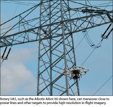
A significant cost-effective application for UAS is monitoring various types of infrastructure and specific locations on a frequent basis. This may include harbor and border control, area and event security, landfills, mines, and pipelines. Safety inspections will particularly benefit when UAS become commercially available. Regular inspections of power transmission lines, pipelines, and bridges will enhance public safety without increasing risk for workers conducting visual inspections.
Agriculture is frequently cited as a growth area for UAS. The traditional methods of aerial imaging, from aircraft or helicopters, are often cost-prohibitive other than for very high-value crops. With UAS, fields can be more frequently flown, which provides more detail and indicates where water, pesticides, and fertilizer needs to be applied to increase yield. UAS are also used for crop dusting and locating livestock. After natural disasters, UAS can map the acreage of crops lost to storms so that farmers receive a fair reimbursement from insurance companies.
UAS can be more cost-effective for traditional topographic mapping of small projects (from just a few acres to several hundred acres), such as landfills, open-pit mines, and coal stock piles, which need frequent revisits. Compared to a large-format system, UAS take more pictures so more processing is involved, but a large-format system is more expensive to mobilize and operate for short flights.
Emergency response, search and rescue, and damage assessment are other highly useful applications for the technology. In areas of difficult terrain or during bad weather, UAS can fly without risking the lives of first responders. After natural disasters, imagery is often used to estimate the cost of rebuilding and the value of insurance claims.
Fields such as real estate, construction, the film and entertainment industry, and accident investigation are all potential markets for commercial UAS operations.
Rotary vs. Fixed-wing vs. Full-size Aircraft
 The choice between multicopter/helicopter UAS technologies and traditional fixed-wing designs requires consideration. Helicopter mapping is not new, but rotary UAS, with their small size and lower costs to operate, open the door to broader applications and markets for services. Because of its ability to maintain a single position in space, a rotary UAS can collect data thoroughly and precisely. Rotary UAS can also fly in restricted or interior spaces, such as under bridges or around power lines, moving horizontally and vertically.
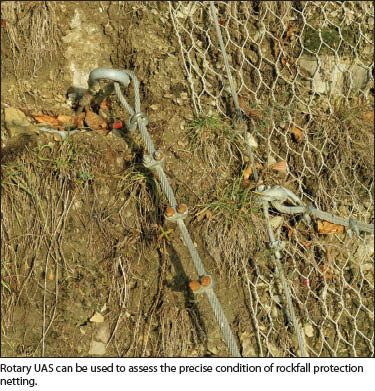
Additionally, a rotary UAS can maneuver close to targets to provide higher-resolution, in-flight imagery. This stability makes detailed inspection work easier to complete. Rotary UAS can also handle applications that require flexibility of movement (i.e. horizontal, vertical, hovering).
Safer, more controlled landings are another advantage of rotary UAS. They require only a small amount of surface to safely take off or land. This added control means rotary UAS can be relied upon to carry more delicate equipment.
As with every technology decision, however, the application will dictate the best approach. A common misconception is that UAS will replace all current forms of aerial data capture. The reality is that projects that are large in scope, such as planning surveys for pipeline routing, will likely continue to be more cost-effective to achieve with a full-size aircraft and a larger sensor.
Additionally, the UAS platform is only part of the package. Professional users will need to carefully examine aspects such as the durability, safety, and ease of use of the system (is it designed for professionals or hobbyists?), the related software (is it fully integrated, fast, and accurate?), and the service and support provided by the manufacturer (is it a startup from someone’s garage or a company with substantial R&D capabilities?).
For the professional, the UAS is a tool that must provide a solid return on investment, and the selection should be made accordingly.
Sidebar
Common UAS Misconceptions
Myth: UAS will make everyone a mapping expert. Fact: UAS are affordable, are easy to operate, and may not even require a pilot’s license to use, depending on the system and the regulations that emerge. As a result, UAS will create aerial mapping opportunities for a much wider group of users than those who have traditionally been able to perform these tasks. However, this doesn’t mean that just anyone will be able to go out and fly a system, come back with the imagery, press a button, and produce high-value deliverables. Because these systems don’t have the same large GNSS IMU sensors that are on full-size planes, achieving good spatial accuracy will require expertise and additional survey work, such as setting ground control.
Myth: All UAS are created equal. Fact: If a system seems too good to be true, it probably is. Look for solutions that are safe, robust, and designed for professionals. Pay careful attention to software and support. An inexpensive “do-it-yourself” system can cost a substantial amount of money in downtime and lost business if it doesn’t produce the required results in a timely manner. Also, make sure the manufacturer is reputable and has a history of standing behind its products long term.
Myth: It’s okay to fly a UAS under 400 feet or on private property. Fact: Much of the conventional wisdom about UAS simply isn’t true. In fact, the FAA recently issued a fact sheet to clarify eight of the most common UAS myths, and these two are on the list. Be sure to check the FAA website or another reputable resource to determine what activities are permitted.
Sidebar 2
Six Steps You Can Take to Prepare
- Begin exploring capabilities and workflows. Some of the most popular professional solutions are affordable and easy to operate, but there’s still a learning curve for successful adoption. Firms that have purchased a UAS are wisely focusing on internal R&D, workflows, and marketing strategies that will give them a competitive edge when the market opens for commercial use.
- Build internal support. The successful integration of a new technology requires an internal champion who invests time in learning about the capabilities and applications and then communicates the benefits to internal stakeholders to achieve widespread buy-in. Developing realistic expectations is a key part of the process.
- Establish relationships with universities and FAA-approved UAS test sites. Universities are actively seeking industry partners that can contribute to the general understanding of the technology and airspace integration issues. Three of the FAA-approved UAS test sites are operated by universities, and there may be opportunities to participate in the other test sites as well.
- Take an active role in industry initiatives. Organizations such as the Association for Unmanned Vehicle Systems International (AUVSI) and MAPPS are working diligently on behalf of professionals to lobby the federal government for commercial approval of UAS. Participating in related task forces, events, and campaigns are just a few ways professionals can support these efforts.
- Respect the regulations. Despite widespread media coverage of operators who have seemingly been able to “get away with” commercial use of UAS, the regulations exist for a reason. Safety is paramount. Continued progress in securing commercial approval requires a professional approach—and that means playing by the rules.
- Do your homework. One of the best ways to prepare for the commercialization of UAS technology is to stay abreast of the latest developments. Make sure the information is coming from a reliable source; even well-intentioned reports in articles and blogs can be misleading. Two good resources are the FAA website and the AUVSI.
Sidebar 3
Online Resources
- For more UAS myths, see “Busting Myths about the FAA and Unmanned Aircraft”: faa.gov/news/updates/?newsId=76381
- Contact information for all six FAA-aproved test sites are on the FAA website: faa.gov/about/initiatives/uas/contacts/
- Unmanned Vehicle Systems International: auvsi.org