May 2019 Archives
The Bullet
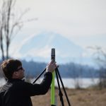
Looking past an unfamiliar form factor reveals hidden strengths of a unique and capable high-precision GNSS field system. I’ll cut straight to the punchline: this little unit performed as well as many of the high-end (and pricier) GNSS rovers I’ve tried, both as a base-rover pair and as a network rover. And I had way […]
Embrace the Mesh
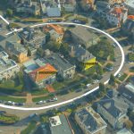
Above: A full 3D textured model of San Francisco produced through Skyline’s PhotoMesh 3D Reconstruction software and streamed for visualization and analytics in Skyline’s TerraExplorer. Surveyors and photogrammetrists capture reality data. But to model, manage, and provide access to massive and complex datasets—to provide your clients with true 3D mesh reality capture—you’re going to need […]
ArcGIS Indoors

What is it, and how will it work? Mapping has traditionally been the task of visually charting big outdoor spaces with pretty hills that look great with a few contours around them. Throw in a bit of hillshade, and you have a cartophile’s dream. The location intelligence company Esri, that has driven the market to […]
No Need to Buy to Fly

A startup took the idea of developing a complete sUAS workflow—hardware, software and processing services—and grew this into a premier sUAS rental/leasing service. Things move fast in the world of UAV/UAS/RPAS/drones. For example, DJI was just another UAV startup company when it was founded in 2006, and the name was not well known to the North […]
Build, Buy, Rent, or Hire?

Seven years ago I was invited to attend a UAS flight course; this was an exciting proposition as the drone craze was not yet under way. In fact, the rules for operating drones in the U.S. were so in flux (as far as commercial and private drone use) that the course had to be held […]
The Evolution of Using Lidar
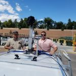
Above: Gary Rust (left) and Anthony Whitlock from Springs Utilities pose with their LiDAR USA HiWay Mapper HD. The history of a Colorado utility systematically deploying lidar technology reveals lidar’s journey as an asset. Located at the base of Pikes Peak on the front range of the Colorado Rockies, Colorado Springs Utilities is a city-owned […]