A startup took the idea of developing a complete sUAS workflow—hardware, software and processing services—and grew this into a premier sUAS rental/leasing service.
Things move fast in the world of UAV/UAS/RPAS/drones. For example, DJI was just another UAV startup company when it was founded in 2006, and the name was not well known to the North American market until five to six years ago. In 2018, the company claimed it has 70% of market share globally. Skycatch—a San Francisco startup company that was founded in 2013—was the first company for which DJI
manufactured a specific UAV per customer specs.
We first took notice of Skycatch when they had a modest booth in the “Startup Zone” of the July 2014 Esri User Conference in San Diego. What we saw was an early iteration of their complete system: a kit you could set up on a construction site, for example, open it up and the drone launches, flies a predetermined area, downloads and processes its own data, and, voilà, you have your daily site volumes.
Even then, major players in the AEC sector were taking notice of Skycatch’s business model, savviness with UAS technologies, and market focus. By November of the same year, we heard that they had received substantial investment capital that has since added up to nearly $50M.
What Does Skycatch Do?
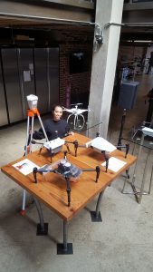
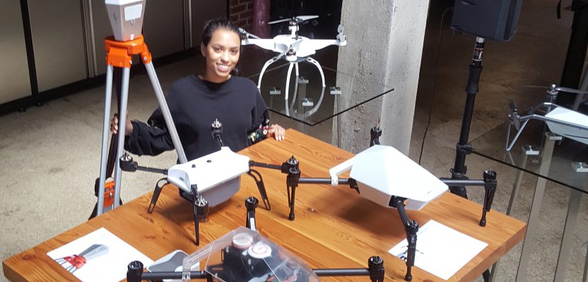
Skycatch’s Farah Wahab stands next to the Edge1 base and a collection of UAS representing the evolution of its products.
Skycatch is a company that aims to shorten your UAS learning curve and see you be productive using a UAS from day one. Stepping into the world of UAS often looks like the following progression:
- Find a UAS that has good reviews and at an acceptable price.
- Generate a lot of data and struggle to learn what to do with all that data.
- Try to find a software package to process images but often wait for hours to get results.
- Decide whether to buy a powerful PC to shorten the processing time.
- Start asking questions about cloud computing and hosted services.
- Deal with damaged UAS from time to time with loss of work.
Imagine getting from “I want a drone” to “here is the result,” skipping all the painful stages listed above. That is exactly the appeal we saw in Skycatch when they were a startup, and we’re long overdue in examining the company, how much it has grown, how these services have been refined and evolved—and taking it for a test drive.
The basics of the Skycatch value proposition are that you get a complete system: UAS with autopilot, mission planning, camera, a GNSS base station (that also does in-field image registration and processing), and an alternative workflow in the cloud to process and perform advanced analysis, and a suite of tools for overlays, markups, and integrations. And you use this as needed.
Contrasting Terms
To put what Skycatch offers in the context of geomatics, geospatial, and AEC within the realm of what folks’ shorthand as “drones,” let’s look at a few common terms.
UAV: unmanned aerial vehicle. It is simply the vehicle, the platform—and one that has become highly commoditized. You can buy one at the big-box electronic store, with or without autopilot.
Start adding sensors, like cameras and/or lidar, flight-planning software, perhaps GNSS, and you have a system; hence, the term UAS for unmanned aerial system. You might also hear the similar term RPAS for remotely piloted aircraft system.
When we speak about most UAS-based mapping and surveying operations for AEC, it is primarily small UAS, or sUAS. Skycatch has a platform that includes an sUAS for precision data collection but also combines all of the other elements for processing, and delivery, and analysis.
We spoke with William Pryor, manager of enterprise solutions for Skycatch, who is also a founding engineer with the company. Pryor reflected on the evolution of the UAS market.
“When we started the company five years ago, you couldn’t buy a drone; you had to build one. Motors, frame, autopilot—put it together, then you could use it. Now you can buy the drones, but you have to put together more things to do mapping and surveying with a drone,” said Pryor.
“Typically, the common way people started mapping and surveying with drones was buy a drone, buy a flight-planning software, buy a rover to set GCPs, buy processing software, buy a computer to process it, host it online, and then you have a data-collection and delivery solution,” said Pryor.
“That piecemeal approach isn’t scalable. We made it our mission to solve that pain point for our customers by creating a fully integrated, turnkey solution designed to streamline implementation and adoption in enterprise operations.”
You might not need to DIY the drone itself from scratch anymore (and become an expert in every- thing that entails), but, putting together and mastering all of the other elements needed to capture, process, and analyze drone data can still represent a substantial investment in hardware, software, and time.
That process might be the last thing someone wants to have to deal with when their focus is on using the data to uncover insights and make data-driven decisions. Now that some very bright minds—experts in this field—have developed a complete rentable solution, you have another option.
Skycatch’s business model is not entirely unique to the UAS market, but as far as we can tell (at this time) it is the only one with as many components and services. It is engineered with sophistication, packaged as a simple service that is very similar to leasing a car.
Easy as 1-2-3
The Skycatch High Precision Package includes everything you need for high-accuracy drone data—Explore1 UAS (the UAV platform is made by DJI, with custom components by Skycatch), a subscription to their online cloud processing and analysis tools, an iPad to plan your mission and view your data on site, and an Edge1 (GNSS base/processing station).
Pricing is tailored to fit enterprise clients’ business needs and includes warranty plus unlimited users, flights, and data processing per site.
This is not just a drone rental. In addition, you will have access to their extensive training materials, 24/7support, and on-site implementation packages. The best part of the deal is having a single company to deal with for all your needs; for any component Skycatch can rapidly provide a replacement to minimize your downtime.
The Explore1 drone and Edge1 are manufactured by DJI to Skycatch’s own specifications. Inside the drone is a built-in Swift Navigation GNSS board. Skycatch and Swift Navigation are only a mile apart from each other in San Francisco, and they have worked closely on this implementation. Swift’s GNSS boards are compact, lightweight, and perform comparable to much costlier boards (see our Sept. 2018 feature about Swift: bit.ly/2UXNGlm).
While the Explore1 drone works as your rover, the Edge1 serves as your base, tapping into your local RTK network, or if you’re in a remote area out of RTK network coverage it can generate its own RTK network. When operated per recommended procedures, the expected result, as stated by Skycatch, is 2 ~ 5cm RMSE (vertical or horizontal).
With the iPad equipped with the Flight 1 app, you can plan your flight path and automate the mission. Put the Edge1 on a tripod and make sure it is somewhat leveled (yes, anyone can do it without needing a tribrach). Setup can be done within five to ten minutes, and the Explore1 is up in the sky flying its mission.
When the mission is completed, remove the SD card from the drone and insert it into the Edge1. Interestingly, the Edge 1 can process the data—create the mosaic and a point cloud with the density of your choice, up to 512 points per square meter—in about 30 minutes. This gives you a quick look at the results before you leave the site so you can see if you missed anything and to look at the general quality of the mission or need to make business decisions quickly, such as making sure a concrete pour was done to match design before it sets.
For more options with resolution, file format, integrations, and analysis tools, you can upload the data to Skycatch’s cloud-processing service.
Once the data is processed, you can export the data to many formats and projections. Skycatch supports localized coordinate systems and data export in TIFF, PDF, LAS, OBJ, DSM, DTM, and contour maps. Common software such as AutoCAD, Civil 3D, ArcGIS, and Bentley are all compatible with Skycatch’s workflow. Indeed, Autodesk was one of the major investors in Skycatch’s 2015 Series B funding.
Pryor showed us examples of customer end-uses: construction-site volume calculations, pre-design topographic mapping, terrain modeling for drainage studies, and one where the customer used the observed 3D point cloud to compare to a 3D design model of a building, revealing deflections in the as-built structure.
Many customers in the construction sector want fast and frequent updates on earthworks progress and aggregates volumes. Skycatch’s business model is well suited for general contractors who already utilize precision data on a site but require a simpler, faster solution. Many of Skycatch’s customers fly daily in order to improve communication across all teams on a project, produce progress reports for stakeholders, and avoid mistakes before they become a change order.
Skycatch Inc. has grown rapidly, with customers like Komatsu, Teck, Anglo American, and a recent announcement of enterprise-wide standardization with DPR Construction.
However, changes in their business model and systems will continue. Skycatch hints at the potential of the AI technology built into their data processing. One can only imagine what AI might bring to this automated process; perhaps cloud-classification and feature-recognition? The constant evolution of their services makes for a strong case for leasing—you always get their latest and greatest.
DIY aerial mapping/surveying (in whole or partial) involves: buy gear, train, learn the software, and refine your own processes. You could always contract someone else to do all that, but now you also have the option to rent as needed. Strong cases could be made for all of the options.
If you do a wide variety of aerial mapping and on a recurring basis, it might make sense to invest in an end-to-end solution. The fact that there are full-fledged options available now is a testament to the ubiquity of drone data and the burgeoning market.
Test Drive
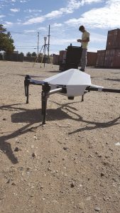
Thierry Colson, surveyor and pilot for Skycatch, preps the Edgel base and Explorer1 UAS for the topo flight.
Skycatch was planning a demo flight near its HQ in San Francisco, and they invited xyht editor Gavin Schrock, PLS to join in. Skycatch has a full-time surveyor on staff, Thierry Colson, who is also a GIS analyst and UAV pilot. Colson took Schrock across the Bay to Treasure Island, a former Naval base that is undergoing massive commercial redevelopment and where Skycatch does much of its testing.
On a vacant lot, Colson set up the Edge1 base and determined its geodetic location by choosing an NTRIP mountpoint on the local Topcon TopNET real-time GNSS network (RTN). In fact, Skycatch hosts a base included in the TopNET RTN on the roof of their HQ across the Bay. The Edge1 base works in the ITRF geodetic system and does so throughout the subsequent processes.
But at the point of creating deliverables, the user can then choose to export in any number of standard transformations and projections. Colson was quick to point this out as it would be one of the first questions a surveyor might ask about the system. The resolved base position is then used for post-fight PPK (post-processed kinematic) processing.
The extent of the lot was then chosen on the iPad from standard online aerial images. Two flights were performed back to back without a battery change as they were relatively short flights (but there are easy-swap batteries for multiple flights). The UAS launched and landed from the same spot, within a foot, as it turned out.
Many UAS use simple autonomous GPS or GNSS to provide a coarse location and orientation for captured images. This is often enough as the images will be digitally matched up to form mosaics. Like Skycatch, most use PPK as it is more reliable and provides a much higher robustness of data, but the real value of the Edge1 is its rapid processing that generates data in 30 minutes or less, the fastest turnaround time in the industry.
Colson removed the SD card from the Explore 1 UAS, inserted it into the Edge 1 base, and initiated the post processing. The images registered, matched, and created a cursory point mesh within about 20 minutes. They were able to look at the mesh on the iPad and see details of the ends of buildings surrounding the site. The terrain looked clean and detailed, what we would expect from 25 points per square meter.
On the drive back, the data were uploading to the Skycatch cloud processing service for a more refined terrain model. In under an hour, two flights were completed and the initial model processed, and that included training a newbie on how to operate the system.